Details and Metadata
Printer-friendly version View XML version Download Ecological Metadata Language file
Methods
The methods followed in the creation of the dataset, including description of field, laboratory and processing steps, and quality control procedures
Current Methods
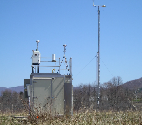
Ozone monitoring
Started: 1987-04-01Ozone is recorded continuously from April 1 through September 30. Hourly average values are available for conversion to biologically relevant units.
Instrumentation: UV Photometric Ozone sampler (US EPA Reference Method)
Quality Control Measures: State of Vermont conducts quality assurance activities
Ozone Monitoring
Started: 1987-04-01Data collected at 0000 hour represents 60 minute average of data collected from 0000-00590100 would be 0100-0159, etc.
Dataset Fields
Detailed documentation of the fields comprising the dataset, including the type of measurement, units where applicable, and any controlled vocabularies or code lists present in the data
Field Name Caption Description Additional Information 24_Hour_GMT 24_Hour_GMT DateTime Date/Time Format: hh:mm:ss 24_Hour_Local 24_Hour_Local DateTime Date/Time Format: hh:mm:ss AQS_Parameter_Desc AQS_Parameter_Desc Nominal County_Code County_Code Date_GMT Date_GMT DateTime Date/Time Format: M/D/YYYY Date_Local Date_Local DateTime Date/Time Format: M/D/YYYY Datum Datum Nominal Day_In_Year_GMT Day_In_Year_GMT Detection_Limit Detection_Limit Horizontal_Accuracy Horizontal_Accuracy Latitude Latitude Longitude Longitude Measurement_Uncertainty Measurement_Uncertainty Nominal Method_Description Method_Description Nominal Method_Type Method_Type Nominal Parameter_Code Parameter_Code POC POC Qualifier_Description Qualifier_Description Nominal Sample_Duration Sample_Duration Nominal Sample_Frequency Sample_Frequency Nominal Sample_Measurement Sample_Measurement Site_Num Site_Num State_Code State_Code Unit_of_Measure Unit_of_Measure Nominal Year_GMT Year_GMT DateTime Date/Time Format: YYYY LocationID Location ID Location ID
Ordinal Date Date Date
DateTime Date/Time Format: YYYY-MM-DD Start Time Start Time Start Time
DateTime Date/Time Format: hh:mm:ss Sample Value sample value Sample value
Interval Units: parts per million Null Data Code Null Data Code Null Data Code
Nominal Sampling Equipment
Equipment and software used to collect data, including how that equipment was used.
Current Equipment
Ozone sampler
UV Photometric Ozone sampler (US EPA Reference Method)
Site Characteristics
The spatial extent of the dataset site coverage, and descriptions of the spatial extent and context for the data collection
- Site Description
Bennington ozone monitoring station: This site is located in a field at rural western end of Bennington, .25 km south west of the Morse Airport, 4.5 km west of the center of Bennington, 1 km north of Route 9, 4 km west of Route 7, 50 km east of Albany, NY. This monitoring location meets all siting requirements and criteria and has been approved by VTAQCD and EPA Region 1
Minimum Altitude: 240.5 meters
Maximum Altitude: 241 meters