Climate
The FEMC Meteorological Monitoring Network
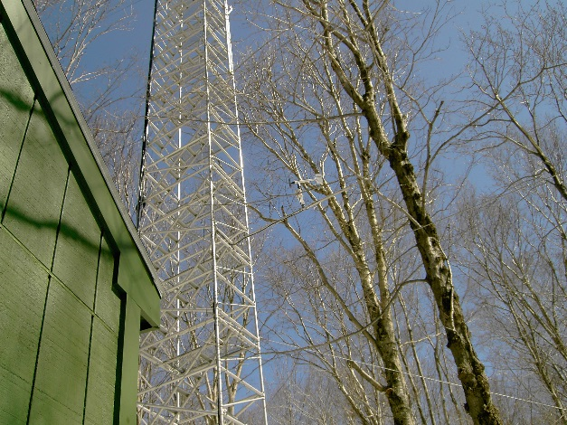
The Forest Ecosystem Monitoring Cooperative (FEMC) has been monitoring weather conditions in Vermont for over 20 years. FEMC currently operates seven meteorological stations across a range of elevations and cover types, maintaining real-time data streams and archiving of long-term data.
Weather and climate are related but very different phenomena, weather being the condition of the atmosphere (precipitation, temperature, etc.) over the short term, while climate refers to longer-term trends and seasonal patterns. Without long-term weather records it would be impossible to tease out short-term (i.e. yearly) anomalies from more ecologically significant climate trends, which makes this information critical to scientists and planners of all kinds. To add temporal and spatial depth to our summary FEMC expanded the climate summary for 2016 beyond the FEMC monitoring stations in Vermont to include trends from the surrounding 11 states (Maine, New Hampshire, New York, Massachusetts, Connecticut, Rhode Island, New Jersey, Pennsylvania, West Virginia, Delaware, and Maryland) using records from the Northeast Regional Climate Center (NRCC) at Cornell University. This regional summary provides a broader picture of emerging trends across a larger region. Much of the following regional summary is adapted from the NRCC annual summary with permission (link to NRCC summary in additional resources).
The Data
Continuous meteorological observations are taken at seven FEMC sites from the shores of Lake Champlain to slopes of Mt. Mansfield. Variables collected include wind speed and direction, air temperature, relative humidity, barometric pressure, solar irradiance, precipitation, and at Lake Champlain stations, water temperature. These variables are primarily logged as 15-minute averages. The longest record comes from the Mt. Mansfield summit station operated by the WCAX transmitter crew and supervised by the National Weather Service, dating back to 1954. Most of the other stations operated by the FEMC began operation in the early to mid- 1990s.
2016 Vermont Summary
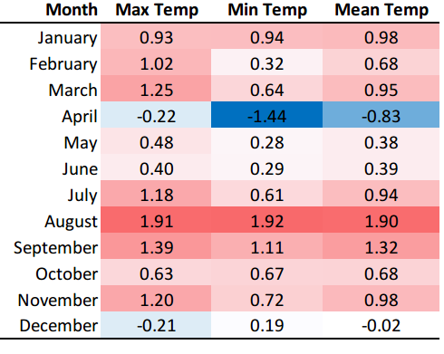
Overall, 2016 was the fifth warmest year on record for Vermont, with above-normal average temperatures recorded at the Mount Mansfield weather station in all months except April and December (Table 5).
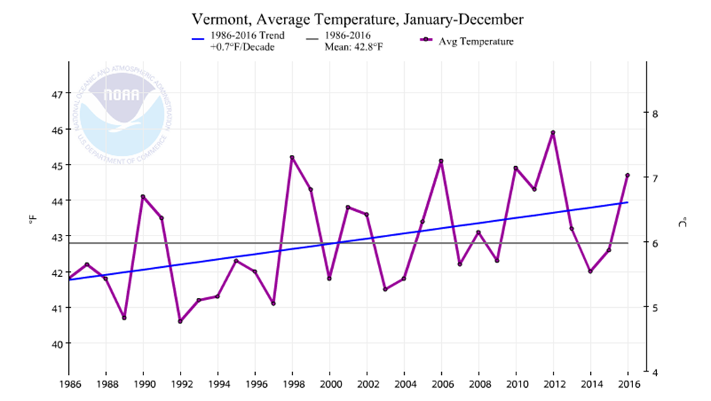
The annual statewide average temperature was approximately 2°F above the average for the last 30 years, and slightly higher than the predicted value based on the last 30 years of record keeping (Figure 16).
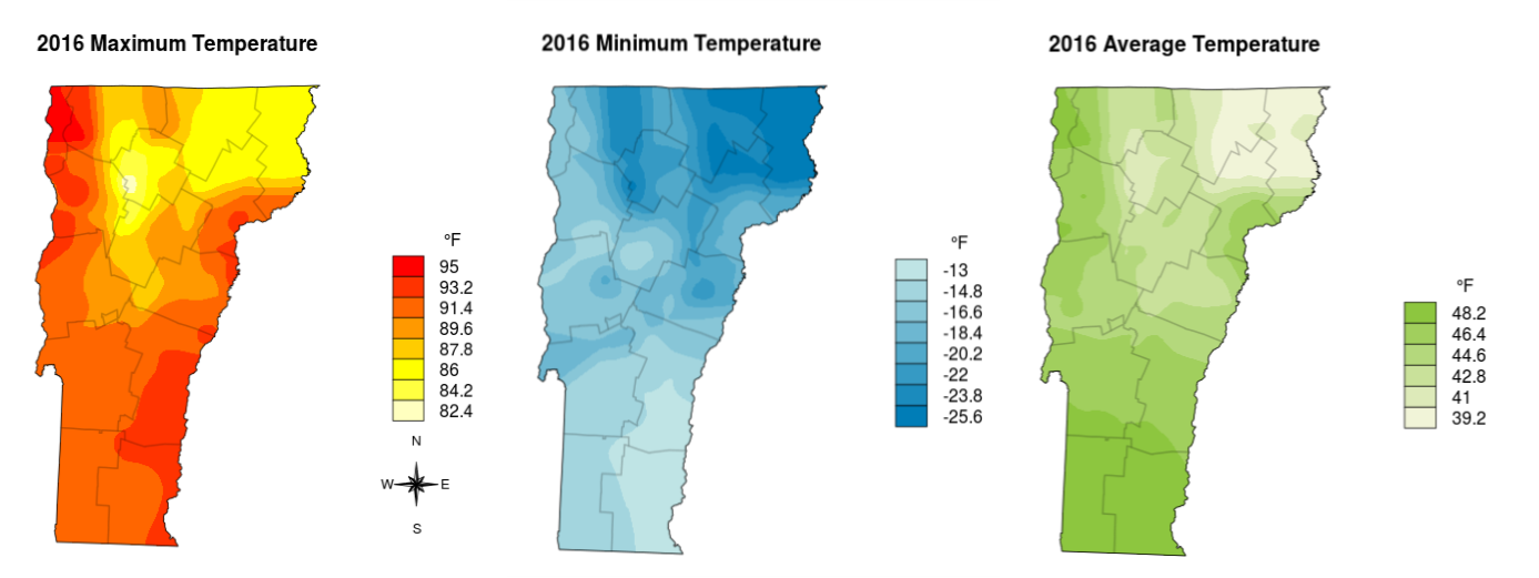
The highest temperature recorded in 2016 was at the Passumpsic station, which saw 100°F on August 12, 2016. The Passumpsic station also observed the highest annual average temperature of 52.8°F. The lowest temperature in 2016 was recorded at the Mount Mansfield station, which saw -32°F on February 14, 2016. The lowest high (i.e. most temperate summer) temperature of 76°F and the lowest annual average of 37.3°F were also observed on Mount Mansfield, while the highest low (i.e. most temperate winter) temperature was in Waitsfield, which observed an annual low temperature of -8°F. Superlative temperatures across the state are mapped across Vermont in Figure 17.
2016 Regional Summary
The climate pattern in the Northeast during 2016 is generally one of warmer than normal temperatures with extreme local precipitation events. Most areas emerged from a warm winter to a hotter than normal summer; for many areas in the Northeast, this meant drought conditions, while for other areas in the Northeast there were periods of extreme flooding. The end of 2016 appeared to be another warmer than normal winter. Although there were local extreme snow events, the winter did not follow a single trajectory across the region.
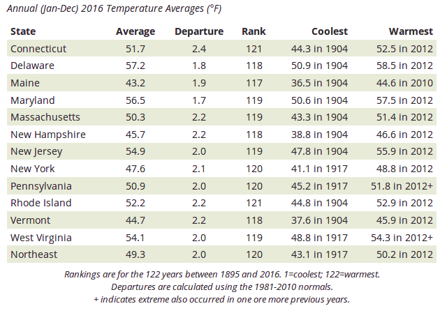
The twelve states of the Northeast had their third warmest year on record in 2016. The region's average temperature was 49.3°F, which was 2.1°F above normal (Table 6). All twelve states ranked 2016 among their top seven warmest years on record.
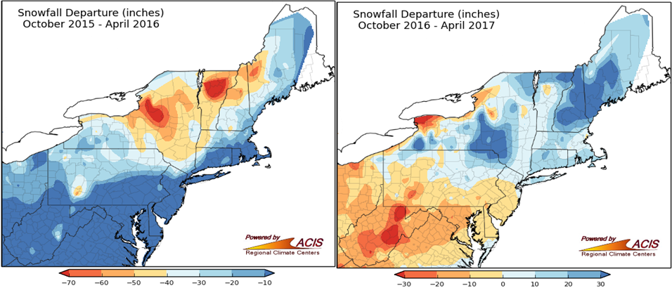
The year started with a warmer than normal winter: winter 2015-16 was the second warmest on record for the Northeast with an average temperature of 31.4°F, 5.4°F above normal. The six New England states each had a record warm winter, while New Jersey and New York both had their second warmest winters. East-central New York had record low snowfall, while deep snow from a single blizzard event fell along the southern New England coast in late January.
In the spring, arctic inputs led to frigid temperatures, particularly in New York and New England in early April. On April 4 and 5, temperatures were up to 30°F below normal, with a few sites having their all-time coldest April temperature on record. The cold spell significantly damaged some fruit crops that had budded early.
Warmer than normal temperatures returned for the summer months. The entire Northeast had its warmest August on record with an average temperature of 71.8°F, 3.7°F above normal. September was the third warmest on record with an average temperature of 64.5°F, 3.9°F above normal. The warm summer was followed by the third warmest autumn on record with an average temperature of 52.8°F, 2.9°F above normal. West Virginia had its second warmest autumn on record, while Delaware, Maine, Maryland, Pennsylvania, and Rhode Island had their third warmest.
Rainfall
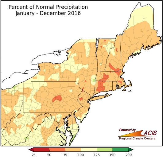
The Northeast wrapped up 2016 with 40.32 inches of precipitation, 91 percent of the long term normal (Figure 18). Ten states were drier than normal, while West Virginia and Delaware were at 101 percent and 106 percent of normal, respectively. It was the third wettest September on record for Delaware and portions of southern West Virginia and central Maryland had 1,000-year flooding events, meaning rainfall of that magnitude has a 0.1% chance of occurring in a given year.
Implications
While climate variability is high, both temporally and spatially, meteorological measurements witnessed across the Northeast are in agreement with local and national assessments indicating that temperatures have increased over the past several decades (Betts, 2011; EPA, 2014; IPCC, 2014). However, it is not the general warming trends that will likely impact forested ecosystems the most in the near future. Instead, it is the increased frequency and severity of extreme climate events that are of concern to forest health professionals. The increase in extreme temperatures witnessed in 2016 are an example of the increase in variability we will continue to see under a changing climate. These extremes represent an additional stress for species adapted to cold weather dormancy, increased risk of winter injury following winter warm spells, and frost damage during spring freeze events. Even when climate conditions remain within a species' natural tolerance, differences in competitive advantages among species due to phenological changes or erratic and unseasonable temperature fluctuations could alter ecosystem structure and function (Pucko, 2014).
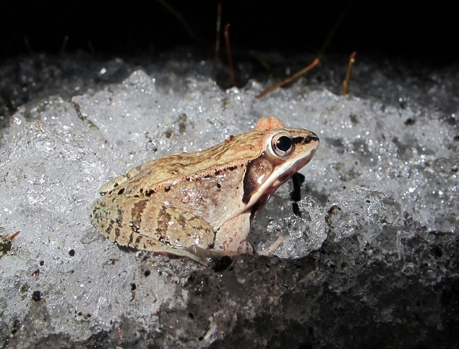
Variable temperatures may eventually affect phenological adaptations, potentially increasing vulnerability to insects, diseases, and may have an adverse impact on major agricultural crops in Vermont such as apples and sugar maples (Grubinger, 2011; Rustad, 2012).
A special thank you to NOAA and the Northeast Regional Climate Center at Cornell University for the generous use of their regional data and their generous permission to adapt the regional climate summary.
References
- Betts, A. K. 2011. Climate Change in Vermont (unpublished report). Available online: http://www.anr.state.vt.us/anr/climatechange/Pubs/VTCCAdaptClimateChangeVTBetts.pdf
- EPA Climate Leaders Summit Report. Summit Date: Friday, November 8, 2013 Johnson & Wales University, Harborside Campus, Providence RI. Report Date: March 2014. Available online: http://www3.epa.gov/region1/climateleaderscollaboration/pdfs/ClimateLeadersSummitReport.pdf
- Grubinger, V. 2011. Climate Change and Vermont Agriculture. University of Vermont Extension. Available online: http://www.uvm.edu/vtvegandberry/factsheets/climatechange.html
- Intergovernmental Panel on Climate Change (IPCC) Climate Change 2014 Synthesis report Summary for Policymakers. IPCC, 2014: Climate Change 2014: Synthesis Report. Contribution of Working Groups I, II and III to the Fifth Assessment Report of the Intergovernmental Panel on Climate Change [Core Writing Team, R.K. Pachauri and L.A. Meyer (eds.)]. IPCC, Geneva, Switzerland, 151 pp. Available online: http://www.ipcc.ch/pdf/assessment-report/ar5/syr/AR5_SYR_FINAL_SPM.pdf
- Pucko, C. 2014. The Impacts of Multiple Anthropogenic Disturbances on the Montane Forests of the Green Mountains, Vermont, USA. University of Vermont, Department of Biology Ph.D. Thesis.
- Rustad, L. et al. 2012. Changing Climate, Changing Forests: The Impacts of Climate Change on Forests of the Northeastern United States and Eastern Canada. Gen. Tech. Rep. NRS-99. Newtown Square, PA: U.S. Department of Agriculture, Forest Service, Northern Research Station. 48 p. Available online: http://www.fs.fed.us/nrs/pubs/gtr/gtr_nrs99.pdf
Additional Resources
- Vermont State Climatologist: http://www.uvm.edu/~vtstclim/
- Northeast Regional Climate Center (NRCC): http://www.nrcc.cornell.edu/
- NRCC Data Online: http://climod2.nrcc.cornell.edu/
- NOAA Climate At A Glance: https://www.ncdc.noaa.gov/cag/time-series/
FEMC Project Database Link
- Burton Island meteorological monitoring https://vmc.w3.uvm.edu/vmcdevel/CI4/data/archive/project/burton-island-meteorological-monitoring
- Colchester Reef meteorological monitoring https://vmc.w3.uvm.edu/vmcdevel/CI4/data/archive/project/colchester-reef-meteorological-monitoring-38-m
- Diamond Island meteorological monitoring https://vmc.w3.uvm.edu/vmcdevel/CI4/data/archive/project/diamond-island-meteorological-monitoring
- Mount Mansfield east slope mid elevation forest meteorological monitoring https://vmc.w3.uvm.edu/vmcdevel/CI4/data/archive/project/mt-mansfield-east-slope-mid-elevation
- Mount Mansfield summit meteorology https://vmc.w3.uvm.edu/vmcdevel/CI4/data/archive/project/mount-mansfield-summit-meteorology
- Mount Mansfield west slope mid elevation forest meteorological monitoring https://vmc.w3.uvm.edu/vmcdevel/CI4/data/archive/project/mt-mansfield-west-slope-mid-elevation
- Proctor Maple Research Center meteorological monitoring https://vmc.w3.uvm.edu/vmcdevel/CI4/data/archive/project/proctor-maple-research-center-meteorological-monitoring
