
Details and Metadata
Printer-friendly version View XML version Download Ecological Metadata Language file
Methods
The methods followed in the creation of the dataset, including description of field, laboratory and processing steps, and quality control procedures
Current Methods
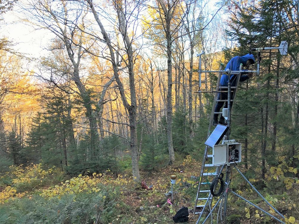
Data from Mount Mansfield station
Started: 1997-01-01This Mount Mansfield station provides basic meteorological variables including wind speed and direction, air temperature, relative humidity, total solar irradiance, photosynthetically active radiation (PAR), and precipitation during non-freezing months. The station is located within a mixed aspen-birch spruce-fir forest, and represents mid-elevation forest meteorology.
Started: 1997-01-01Data are automatically downloaded via radio frequency (RF) modem on a daily basis, with 15 minute average records collected and stored during each downloading cycle. Hourly and daily data formats are made available.
Dataset Fields
Detailed documentation of the fields comprising the dataset, including the type of measurement, units where applicable, and any controlled vocabularies or code lists present in the data
Field Name Caption Description Additional Information RECORDTIME Record timestamp Time and date of measurement
DateTime Date/Time Format: YYYY-MM-DD hh:mm:ss SAMPLEYEAR Sample Year Year when sample was collected
DateTime Date/Time Format: other SAMPLEMONTH Sample Month Sample month of data collection
DateTime Date/Time Format: other SAMPLEDOY Sample Day of Year Day of year when collected
DateTime Date/Time Format: other SAMPLETIME Sample Time Time of sample collection
DateTime Date/Time Format: other AIRTEMP Air Temperature Measured air temperature
Interval
Unit: celsuis
Precision: 0.01RELHUMID Relative Humidity Relative humidity
Ratio Units: dimensionless
Precision: 0.01QUANTUM Photosynthetically active radiation Photosynthetically active radiation (400nm to 700nm)
Ratio
Unit: umolePerSecondPerMeterSquared
Precision: 1PYRANOM Solar radiation Solar radiation flux
Ratio
Unit: wattsPerMeterSquared
Precision: 1PRECIP Total Precipitation Total precipitation
Ratio
Unit: millimeter
Precision: 0.1MAX_WINDSPEED Maximum Wind Speed Maximum measured wind speed
Ratio Units: meters per second
Precision: 0.001TIME_MAX_WINDSPEED Time of Maximum Windspeed Time during the measurement interval of maximum measured wind speed
DateTime Date/Time Format: other MEAN_HORIZONTAL_WINDSPEED Mean Horizontal Windspeed Mean horizontal windspeed during the measurement interval
Ratio Units: meters per second
Precision: 0.001MEAN_RESULTANT_WINDSPEED Mean Resultant Windspeed Mean resultant windspeed over the measurement interval
Ratio Units: meters per second
Precision: 0.001MEAN_WIND_DIRECTION Mean Wind Direction Mean wind direction during the interval
Ratio
Unit: degree
Precision: 0.1STDDEV_WIND_DIRECTION Standard Deviation of Wind Direction Standard deviation of wind direction over the measurement interval
Ratio
Unit: degree
Precision: 0.01Sampling Equipment
Equipment and software used to collect data, including how that equipment was used.
Current Equipment
Data logger, weather sensors, rain gauge
Started: 1997-01-01Campbell CR 10X datalogger with automated weather station sensors on a 3 meter tower. Tipping bucket rain gage (unheated).
Site Characteristics
The spatial extent of the dataset site coverage, and descriptions of the spatial extent and context for the data collection
- Site Description
West slope of Mount Mansfield, in the Browns River watershed, off the CCC road within paper birch, spruce and fir forest. Approximate coordinates: 44.5244 N, 72.8267 W. Approximate elevation: 2678 feet
Dataset Notes
Notes describing any special conditions or considerations for understanding the quality and consistency of the data
Start Date End Date Note Date Entered 2025-12-17 00:00:00 2025-12-17 23:59:59 BP charged battery and cleaned off solar panel 2026-03-09 13:31:54 2025-12-09 00:00:00 2025-12-09 23:59:59 BP replaced temp rh sensor and charged battery 2026-03-09 13:30:47 2024-10-02 00:00:00 2024-10-02 23:59:59 Replace the temp/RH sensor with a newly calibrated unit. 2026-03-09 13:27:59 2023-10-02 00:00:00 2023-10-02 23:59:59 BP, JL, and JV went up to replace the temp/RH sensor on 10/02/2023. Datalogger turned off at 1117 and back on at 1127. 2023-10-09 12:36:06 2023-01-17 00:00:00 2023-01-17 23:59:59 BP went up to check on battery. Cleared off solar panel and checked batt voltage. 11.8V. Needs to be charged. Checked the solar tracker app (sunseeker) and concluded that the sun does not rise above Mansfield from November-January. The solar panel does not receive any sun during that time. Need to hike up with a power bank to charge the battery when it drops below 12v during these months. 2023-01-18 16:32:51 2022-10-27 00:00:00 2022-10-27 23:59:59 BP and HM went up to replace a dead battery, upload a new program for the CR1000x and trim some tree branches that were shading the panel. We successfully uploaded the new program and replaced the battery. We also bagged the precip gauge for winter. The old battery was dead at 9v and was replaced by a larger 100AH battery. We cut some smaller trees to the SW that were encroaching and shading the panel, but I think if we are going to make a real difference with the shading we are going to need to cut down 5-6 of the large trees that shade the panel substantially. It may be good to buy a portable charger we could hike up to top the battery off with in the winter before the battery drops below 50% (12.0v). Once it drops below 50% it can damage the internal cells of the battery. 10.5V is 0% and permanently damages the cells in the battery, which is what seems to have been happening over the years. 2022-10-27 13:47:33 2022-04-21 00:00:00 0000-00-00 00:00:00 AB & BP changed out sensors. Temp/RH, New SN: 20141600193496. Temp Cord, New SN: 201516000344B9 2024-03-14 16:45:48 2022-02-11 00:00:00 2022-02-11 23:59:59 JD & AB cleaned off snow from solar panel & changed out sensor battery (New SN HVHKL. Old SN EIGAT) 2024-03-14 16:40:17 2022-01-06 00:00:00 2022-01-06 23:59:59 AB and NC visited MMW on 1/6/2022 in an attempt to determine cause of station being offline. Solar panel was covered in snow so we wiped this off an 11:25am. We opened the battery box and battery was dry. Checked voltage which was at 4.05. Determined that cold weather in combination with a covered solar panel is probably the cause of the drained battery. Datalogger turned off at 11:44am, turned on at 11:53am. Wind gauge was rotating and propellers were turning. There was a light snowfall at the time. Will need to replace battery. 2022-01-13 16:23:52 2021-11-04 00:00:00 2021-11-04 23:59:59 JT and NC went up to MMW to replace the battery. 2022-01-19 10:40:18 2021-11-02 00:00:00 2021-11-02 23:59:59 NC went up to MMW because as of 10/24/2021 MMW has been offline. NC found that there was water in the battery case and the voltage was extremely low. JT and NC will replace the battery soon. 2021-11-03 12:23:07 2021-10-25 00:00:00 2021-10-25 23:59:59 JT noticed that MMW went offline and reviewed the data. This revealed that the battery voltage began dropping below 10 V on 10/17/2021 at 8:00 AM EST. We will make a trip out to replace the battery, however the weather in general has been very cloudy and the area is becoming more dense, making it difficult for sun to get through. As of today the station keeps coming in and out based on how much the battery can charge up. 2021-10-25 09:20:58 2021-09-30 00:00:00 2021-09-30 23:59:59 JT and NC went out on 09/30/2021 to MMW to swap out the pyranometer, quantum and temp/rh probe. Station off at 10:21 AM EST and on at 1125 EST. The PY and Qu should definitely use the longer cable models. We had a longer PY but the Qu was installed using an extension cable. The rain gage was covered using a garbage bag at around 10:45 and will be closed for the season, we will look into opening it back up once the snow thaws next spring. The gage was extremel clogged and overflowing when we arrived, the data prior will likely need to be nulled. The new sensors installed were ID 60, 32, and 30. The old sensors were IDs 56, 143, and 34. The battery was kept at the site as it looked like it was still producing good voltage. The new program is called 20210929_MMW_Program_Final.CR1X. The desipack was also swapped out. 2021-09-30 14:31:20 2021-05-21 00:00:00 2021-05-21 23:59:59 05/21/2021 JD went up to MMW to swap out the CR10X with a newly updated CR1000X. JT updated the OS which should resolve the issue with the logger dying when temperatures drop below freezing. PB address for Cr1000X = 88. Radio Modem ID = 88 and SDC =7. Wiring diagram used was called 20191011_MMW_CR1000X_WiringDiagram_Modified2.pdf and the program uploaded was called 20200820_1208PM_MMW_Program_Final.CR1X, both are in the 20210521_MMW_Visit notes in the idrive. There was some condensation inside of the logger box. This was likely due to a piece of the wiring diagram being exposed and wicking water in. For the next visit the team should replace the desipaks, new putty, level the rain gage (bring a level). JD left the new interstate battery. Interstate confirmed it takes 12-15 months before the battery begins to lose power. The battery was left there in February of 2021 and should be fine until February of 2022. Additional notes in 20210521_MMW_Visit folder on idrive. 2021-05-21 11:04:45 2021-04-28 00:00:00 2021-04-28 23:59:59 EG and MS went out to MMW to collect data from the CR10X. Only small patches of snow left on the ground near the site. The spare battery in the trash bag had tipped over onto its side when the snow melted and slid down the slope <m. There was some water in the trash bag. We inspected the battery, it did not appear to have leaked (we did not check the voltage). We dried out the bag to the best of our abilities and rewrapped the battery in the trash bag and stored it in a more secure location near the ladder just north of the met station. We successfully connected to the data logger and pulled the data. The air temp was around 45 deg. The weather overcast with a light breeze from the NNW. The CR10X has enough memory to collect data until May 27th, 2021. 2021-04-28 13:39:37 2021-03-30 00:00:00 2021-03-30 23:59:59 EG and MS went out to MMW to collect data from the CR10X. The solar panel was not covered in snow, and neither was the battery. The spare battery in the trash bag is starting to become exposed. We successfully connected to the data logger and pulled that data. Upon looking at the data there are a few entries (one at a time spread throughout) that only have data in the first 5 columns, and there is one column that only shows a 0 for every entry. Other than that the data looked fine. WE check the battery voltage which was 11.7 volts at 10:30. The logger was never turned off. The temp was around 30 deg. The CR10X has enough memory to collect data until May 4th, 2021 2021-03-30 16:25:54 2021-02-26 00:00:00 2021-02-26 23:59:59 JT and EG went out to MMW to change the CR1000X for a static CR10X. This swap was necessary because campbell sci mentioned that the CR1000X could potentially be facing hardware issues in freezing temperatures. Upon arrival the solar panel was again covered in snow and ice and the battery voltage was 3 volts. After scraping off ice and snow from the panel and allowing it to charge for an hour, we were able to get the battery back up to 12 volts. The logger was turned off at 11:16 AM EST and turned back on at 12:24 PM EST. The temp was around 10 deg so the lock was frozen. The CR10X has enough memory to collect data until April 1st 2021. The CR1000X will be tested at spear st to ensure it can be repaired by campbell. Program on CR10X is 20200820_Retrieved_CR10X_MMW.dld. The wiring diagram is in the box and in the idrive site visit folder for that date. 2021-03-01 11:30:45 2021-02-16 00:00:00 2021-02-16 23:59:59 JT noticed that the MMW site went back online at 12:15 PM on 02/12 and died at 4:00 PM EST. During that period the battery voltage appeared a couple of times reading a voltage of 2.9 with a temperature of -6 to -22 C. The logger came back on again on 02/13/21 at 11:30 AM EST and died at 4:30 PM EST. The logger seems to come online when the sun is the strongest and dies in the evening. 2021-02-16 11:58:26 2021-02-11 00:00:00 2021-02-11 23:59:59 EG and JT went out to MMW to troubleshoot why the site went down on 01/15/2020 @ 7:30 AM EST. Upon arrival we noticed there was 2 feet of snow on the solar panel, looks like the heater on the panel does not work. We also struggled with the lock, bring new deicer next time. After allowing the station to charge up everything came back online. We brought a new battery to use as a replacement but when we checked the voltage of the old battery it ready 11 volts so we left the new battery (#211) in a garbage bag under the station. We also removed the wires for the temp/rh probe as this sensor continually dropped signal, we were afraid it was shorting the logger. After returning to the office we noticed that the station went offline again at 4:15 PM EST on 02/11/2021. We need to go back to the site to investigate. 2021-02-12 07:45:02 2020-08-20 00:00:00 2020-08-20 23:59:59 JT and AB went out to MMW to change out Temp RH (F5030027) with TempRH (T0330026) and deploy the CR1000X and pull the CR10X data. Upon arrival the precipitation gauge was clogged and had to be unclogged at around 9:10 AM. The precip gage was put together at 9:18 AM. All of the CR10X data was pulled at 09:37 AM. The data goes from July 8th 9:00 AM until August 20th at 8:15 AM. Powered off at 9:44 AM. TempRH replaced at 9:54AM. Unplugged everything from CR10X at 10:23AM. The CR1000X had an original PB of 1 and it was changed to 88 to made the modem. The RF500M had a PB of 88 and SDC of 7. The new program was called 20200820_1208PM_MMW_Program_Final.CR1X. Note that the variable RH_2 had to be changed to RH. Time on an 12:03 PM (notice this is standard time and not daylight savings time. We were not able to test communications with RSEL because the rsel computer would not allow anyone to connect into it. 2020-08-21 08:36:17 2020-07-02 00:00:00 2020-07-02 23:59:59 JT went to pull data from MMW Cr10X. The data ranged from day 141 (May 20th) to day 184 (July 2nd). The latest data was a 0800. The rain gauge was also clogged upon arrival and was cleared out. There was a pool of water sitting at the top of the gauge. Currently the CR1000X meant for the site is being tested and will be deployed likely on the next trip. The CR10X currently at MMW will need data pulled by August 11th 2020. 2020-07-02 11:09:29 2020-05-26 00:00:00 2020-05-26 23:59:59 JT went to MMW to pull data off of CR10X. Memory should be available until July1, 2020. 2020-06-30 13:46:06 2020-04-29 00:00:00 2020-04-29 23:59:59 JT went out to MMW to retrieve data from the CR10X and clear the rain gage. The data that was available March 24 to April 29th at 9:00 AM. We lost data from March 11th to March 24th. This collected approximately 36 days of data. The data will need to be cleared from the CR10X by June 1, 2020. The data pulled from the logger can be accessed on the visit folder in the MMW folder on the idrive. The data will be uploaded to the db to fill in the missing data. There was still snow present on mansfield. Loggernet was not on the laptop brought out in the field so the free PC200W program from campbell was used instead. 2020-04-29 16:02:03 2020-03-11 00:00:00 2020-03-11 23:59:59 JT and JVD went out to MMW with a new battery to see if that would resolve the -19 voltage issue the CR1000X logger was reading. The old battery had a reading of 7 volts on arrival. The new battery read 12.7 volts. The battery was able to make it possible to communicate with the datalogger remotely, however that did not resolve the issue of the -19 volts reading. JT, pulled all terminals and the modem from the logger and using usb connection saw that the -19v was still present even with nothing connected to the logger. We powered the logger off at 10:32 AM EDT and then powered it back on at 10:50 EDT. We worked with campbell to resolve the issue in the field with no luck. I ultimately removed the CR1000X and replaced it with a CR10X at 2:00 PM EDT. The wiring diagram for the CR10X is in the logger box and the program used is in the MMW 2020 programs folder in the idrive. The cables for the box have also been properly labeled. Future plans will consist of heading back out there to retrieve the data from the CR10X and then replacing the CR1000X after fixing it. 2020-03-12 13:49:55 2020-03-02 00:00:00 2020-03-02 23:59:59 JT visited MMW to figure out while the station has been offline since 01/28/2020. Upon arriving at the site, I realized that the station was engulfed in snow. Power off at 11:30 AM. What likely happened is the solar panel got covered in snow and the battery no longer had enough power to get itself back up to a workable level (Campbell sci suggest ~9.6 volts). When the battery was tested it read 3.97 volts. When I tested the terminals going to the battery it read ~4.7 volts. While on the phone with Campbell Sci we concluded that the station likely needs a new battery. Data from the station from 02/23/20 to 02/26/20 was showing voltage dropping slowly and then finally blacking out at 8.84 volts. The -19 voltage issue was not resolved but I did replace the SC12 cord going to the RF500M as suggested by campbell. Power on at 12:34 PM. Additional note: The correct coordinates to get to the site is 44.52366, -72.82657. The cut in point from the CCC road is 44.52376, -72.82735. The station is roughly 200 ft from the ccc road going east. During the winter, XC skis might be nice for the ascent up but you'll deff need snowshoes once you start climbing to the station. Will visit site soon to bring new battery and troubleshoot -19 volt issue is still happening. 2020-03-02 16:26:23 2020-03-02 00:00:00 2020-03-02 23:59:59 JT went out to MMW and noticed that the data was offline on 01/28/2020 at 2:45 AM but then it came back online and uploaded data from 02/23/2020 at 12:15 PM to 02/26/2020 at 10:45 AM then it cut off and read data from 03/02/2020 at 12:15 (This was from manually plugging into the datalogger). 2020-03-02 16:24:22 2020-02-14 00:00:00 2020-02-14 23:59:59 MMW data collection has abruptly stopped on 01/28/2020 at 2:45 AM. JT will visit the site and figure out why this is. 2020-02-14 08:33:08 2019-11-07 00:00:00 2019-11-07 23:59:59 Beginning at around 8:30PM EST the battery at the site began reading -19 volts. This occurs off and on with no consistent patters. When the battery drops the temp/rh readings go out. This note was inputted on 11/12/2019 and the issue is still occurring. Will make a site visit soon. 2019-11-12 15:44:58 2019-10-11 00:00:00 2019-10-11 23:59:59 Left a ladder at the site. It should be under a fallen log (~14" DBH) 2019-10-14 15:23:34 2019-10-11 00:00:00 2019-10-11 23:59:59 On 10/11/2019 JD, JT and JVD went to MMW to replace the comms equipment. Arrived at around 7:30 AM and left around 11:30 AM.The CR10X (2994) was swapped with CR1000X (10361). The DL3400 radio (341007166A44967) was swapped with Ritron UHF radio (A100506321). RH95 Modem (4175) was swapped with RF500M (5298). We replaced the quantum (Q46093), pyranometer(PY102366), and the nose cone of the RM Young 05305. The new sensors are, quantum (Q40363) and pyranometer (PY47780). The wind bird just required swapping a nose cone with new bearings. We also found that the bird was roughly 180 degrees off from north. This was determined by a compass. We rotated the base of the windbird so that it was oriented in the right direction. We might need to review historical data to see if we need to correct the wind direction. The body of the windbird also was too short for the nose cone we brought out so we placed two o-ings to prevent the bearing from rubbing against the internals of the unit. The tail also separated from the body so we used masking tape to fix it up. Need to replace next visit. We noticed that at this site the temperature probe used a 7 wire connection instead of the 6 at the lake met stations. This was modified in the program. We also leveled the precip gauge and the sensors on the station. Next time we go out we need to get a new temp/rh weather shield, tighten the guy wires and anchor with rebar, and we need to put up some additional reflective marking to prevent someone from running into it.We were unable to label the cables this time around. Need to bring masking tape next visit. 2019-10-14 14:08:19 2019-10-11 00:00:00 2019-10-11 23:59:59 RM Young Wind Vane height is 3.75m. Quantum and pyranometer height is 3.72m. Temp/rh probe height is 2.5m. This note will be updated with the remainder of the activities that occurred on 10/11/2019. 2019-10-11 15:50:17 2019-10-01 14:00:00 2019-10-01 15:00:00 Station maintenance visit by JAD, removed HMP (s/n Y2850113) temp probe and replaced with calibrated unit (s/n F5030027). Cleared tipping rain bucket which was clogged, will nullify precipitation data back to last visit as station was not visited in spring. Noted that RM Young bearings are noisy and need to be replaced. Pyranometer and Quantum need to be replaced. 2019-10-02 13:17:49 2019-03-05 16:15:00 2019-03-05 16:45:00 Replaced battery. Pyranometer and quantum were covered with snow, as well solar panel. Solar panel was cleared. Wind bird was turning and spinning. At least four feet of snow at site. Battery was below the downhill tripod leg, lookers left/skiers right. Had to cut the strap holding the top to the battery box as it was frozen so bring a new one up at next visit. Also had to use lock deicer to free combo lock - be sure to bring this with you in winter. 2019-03-11 10:47:25 2018-12-04 15:03:00 2018-12-04 15:20:00 Powered down logger in order to replace HMP. Probe had been reading RH values around 112%, which is a lot of percents. Verified with Jim that new one is reading reasonable temp and RH values (-11C and 78% RH). Add lock deicer to field backpack kit. Swapped out Z1050094 with Y2850113. 2018-12-05 08:17:50 2018-07-24 00:00:00 2018-07-24 23:59:59 Mike Finnegan visited the site to swap out the battery (G6NAB) with a new battery (F81FB) and the wire for the temp RH probe was cut by rodents and was soldered and reinstalled the temp/rh probe. The station was shut down at 1330 and turned back on around 1412. 2018-07-25 09:41:59 2018-07-17 14:11:00 2018-07-17 15:05:00 Cleared rain gauge of debris @ 1411 EDT. Investigated the HMP and found a critter had once again chewed through the cable, so data is bad since 2017-08-18, not long after the radiation shield was replaced. HMP taken down, disconnected from logger, and will try to repair. Tightened guy wires, replaced desiccant, and checked putty. 2018-07-18 09:31:52 2017-08-08 00:00:00 2017-08-08 23:59:59 Replaced radiation shield on HMP due to excessive filth on old one. Replaced at ~1450 EDT. 2017-08-10 13:09:13 2017-07-26 00:00:00 2017-07-26 23:59:59 Secured the third guy wire that was loose with a piece of rebar 2017-07-27 15:27:31 2017-07-18 00:00:00 2017-07-18 23:59:59 Station visit. Changed out temperature/RH probe with a freshly calibrated probe. Tipping rain gauge was clogged, so cleared that out too. Precipitation data nullified from 10/15/2016 through 7/18/2017. Two guy wires stabilizing the station had been broken, but the station had not been shifted. One wire was reconnected. 2017-07-27 14:38:46 2016-07-19 13:30:00 2016-07-19 15:00:00 Replaced MMW quantum, pyranometer and battery; checked wind anemometer and precipitation gauge. Precipitation gauge was clogged with plant debris, cleaned it out. Have not nullified data yet. 2016-07-20 00:00:00 2016-02-17 23:30:00 2016-04-21 11:15:00 At MMW, some critter bit through the cable that connects the air temperature and relative humidity sensor to the data logger. The sensor and cable were replaced and are functional now. 2016-05-31 14:45:00 2014-02-26 22:45:00 2014-05-15 09:45:00 Battery charge dropped too low, station shut down until spring visit in May. No data collected. 2015-09-28 00:00:00 2013-05-06 10:00:00 2013-05-06 10:15:00 Rain gauge opened for the season. Precipitation nullification ended 2013-05-06 15:15:00 2012-11-12 11:00:00 2012-11-12 11:15:00 Rain gauge at the site was closed for the season. Subsequent precipitation records nullified until gauge reopened 2013-05-06 15:15:00 2012-09-09 18:00:00 2012-09-09 18:15:00 Cleared out rain gauge 2012-09-10 00:00:00 2012-08-27 11:30:00 2012-08-27 12:00:00 site cleaered with loppers and handsaw. Tower wires restrung. raingauge cleaned. desi packs changed.Replaced temperature/humidity probe and pyranometer and quantum for calibration purposes. 2012-08-28 00:00:00 2012-07-06 10:00:00 2012-07-06 10:30:00 Rain Gauge cleaned. nullified precip data for 10:00 2012-07-06 01:00:00 2012-06-19 10:30:00 2012-06-19 10:30:00 Rain Gauge cleaned and branches trimmed back from anemometer. nullified precip data for 10:30 2012-06-20 15:30:00 2011-06-06 00:30:00 2011-06-06 13:00:00 Rain Guage opened for the season. Other instruments not touched, however jostling of the tower may have occured. 2011-06-06 15:44:00 2010-11-12 08:45:00 0000-00-00 00:00:00 Rain Gauge closed for the season 2010-11-18 00:00:00 2009-11-10 10:15:00 0000-00-00 00:00:00 Pending. rain gauge closed for the season at 10:15 am EST, changed desiccant,change RM Young anemometer nose cone assembly all instruments visually inspected and instantaneous data values checked 2010-05-13 11:19:00 2009-08-14 11:00:00 0000-00-00 00:00:00 Unclogged rain gauge at 11:00 am, air temperature/relative humidity probe changed for calibration purposes pyranometer changed for calibration purposes quantum sensor changed for calibration purposes all instruments visually inspected and instantaneous data values checked changed desiccant 2010-05-13 11:40:00 2009-07-03 05:00:00 2009-07-13 11:00:00 Rain Gauge was clogged - JG 2009-08-03 16:33:00 2008-12-03 00:00:00 2009-05-13 10:50:00 Rain gauge closed for the season 2010-05-13 11:25:00 2007-11-14 11:45:00 2008-06-09 10:00:00 Rain gauge closed for the winter 2008-01-17 16:29:00 2007-06-22 01:30:00 2007-09-25 09:30:00 Tipping bucket (rain gage funnel) blocked. Nullified from June 22, 2007 at 1:30 EST to July 25, 2007 at 9:30 EST. 2008-02-12 19:28:00 2006-11-29 09:45:00 2007-05-14 12:00:00 Tipping bucket covered Nov 29 2006; at approximately 09:45 AM. 2007-02-16 16:24:00 2006-09-28 09:30:00 2006-09-28 09:45:00 ***Added battery voltage variable*** 2007-02-16 16:24:00 2006-09-28 09:30:00 2006-09-28 09:45:00 Changed anemometer nosecone assembly, upgraded air temperature/relative humidity sensor from HMP35C to HMP45C. 2008-02-12 19:13:00 2006-09-28 00:00:00 2006-09-28 23:45:00 Tipping bucket (rain gage) found clogged 2008-02-12 19:18:00 2006-09-23 10:30:00 2006-09-28 09:45:00 Tipping bucket (rain gage) found clogged 2008-02-12 20:09:00 2006-09-06 02:45:00 2006-09-28 09:30:00 Tipping bucket (rain gage) found clogged 2008-02-12 20:06:00 2006-07-05 07:30:00 2006-07-31 09:45:00 Nullified precipitation data from 7/5/06 at 7.30 to 7/31/06 at 9.45 inclusive due to a clogged rain gage 2007-02-16 16:24:00 2005-11-21 11:00:00 2006-05-31 10:30:00 Tipping bucket covered Nov 21 2005 approx 11.00 AM EST. Tipping bucket opened May 31 2006 approx 10.30 AM EST' 2007-02-16 16:24:00 2005-10-05 00:00:00 2005-10-05 00:00:00 Replaced temperature/humidity probe and pyranometer and quantum for calibration purposes. 2008-02-12 19:02:00 2005-09-01 15:00:00 2005-10-05 23:45:00 Tipping bucket found completely clogged and full of water; began ~15:00 EST on 9/1/05. 2008-02-12 19:07:00 2004-11-11 10:15:00 2004-11-11 10:45:00 Temp/rel humd probe changed for calibration; off-line from approx.10.15 - 10.45 am EST. 2007-02-16 16:24:00 2004-10-26 10:30:00 2005-05-05 00:00:00 Tipping bucket (rain gage) covered on Oct 26 2004 at ~10.30 am DST. 2007-02-16 16:24:00 2004-06-09 11:45:00 2004-07-15 14:30:00 Tipping bucket blocked; set records to null from June 9 11.45 PM - July 16 14.30 DST/15.30 EST 2004 2007-02-16 16:24:00 2003-11-12 09:30:00 2004-05-13 00:00:00 Tipping bucket (rain gage) covered on 12 Nov 2003 approx. 10.30 A.M. 2007-02-16 16:24:00 2003-10-28 00:00:00 2003-10-28 23:45:00 Changed pyranometer and quantum for calibration purposes. 2008-02-12 15:47:00 2003-10-27 13:45:00 2003-10-28 14:45:00 Rain gage found blocked by leaves. Set to null precipitation records from 10/27 1.45 am to 10/28 14.45 EST 2007-02-16 16:24:00 2003-09-11 00:00:00 2003-09-11 23:45:00 Changed anemometer nosecone assembly. 2008-02-12 15:45:00 2003-09-09 00:00:00 2003-09-09 23:45:00 Temperature/relative humidity probe replaced for calibration purposes. 2008-02-12 15:44:00 2003-07-09 00:00:00 2003-07-09 00:00:00 Tipping bucket funnel found on ground and restored to original position. 2007-02-16 16:24:00 2002-10-17 10:15:00 2003-05-20 00:00:00 Tipping bucket (rain gage) covered. 2007-02-16 16:24:00 2002-10-17 00:00:00 2002-10-17 00:00:00 Temperature/relative humidity probe replaced for calibration purposes. 2008-02-12 15:32:00 2001-11-19 00:00:00 2002-05-08 00:00:00 Tipping bucket (rain gage) covered. Deleted records to October 16 2001.' 2007-02-16 16:24:00 2001-09-06 00:00:00 2001-09-06 23:45:00 Temperature/relative humidity probe replaced for calibration purposes. 2008-02-12 15:21:00 2001-06-01 00:00:00 2001-06-01 00:00:00 Changed pyranometer and quantum for calibration purposes. 2008-02-12 15:18:00 2001-05-29 00:00:00 2001-05-31 09:00:00 Due to low battery voltage some data not collected between 5/29/01 and 9 am EST 5/31/01 2007-02-16 16:24:00 2001-05-17 01:00:00 2001-05-17 12:45:00 Met station battery replaced; station somewhat operational. 2001-05-23 00:00:00 2001-04-24 09:00:00 2001-05-18 08:00:00 Met station fell down. Wind data ends at 0845. After 0915 no more of any data. Reset date/time stamp. 2001-05-23 00:00:00 2001-04-24 08:45:00 2001-05-18 09:00:00 Deleted 4/24/01 0845-0915. No further records entered until 5/18/01 0900 (due to time stamp change to 2000). 2007-02-16 16:24:00 2000-12-04 00:00:00 2001-05-18 00:00:00 Tipping bucket closed. Had been frozen for a while. Deleted records from Oct 28th on. 2001-02-22 00:00:00 1999-12-09 00:00:00 2000-06-01 11:00:00 Tipping bucket closed for season 2000-10-31 00:00:00 1998-10-21 08:45:00 1999-05-03 11:30:00 Tipping bucket closed for winter. It was plugged with leaves and overflowing. Check data and correct. 2000-10-13 00:00:00 1998-09-07 00:00:00 1998-10-21 13:00:00 rain gage clogger and overflowing 2008-02-12 19:39:00 1997-11-07 00:00:00 1998-05-29 12:00:00 Noon; Tipping bucket closed for winter. 2000-10-13 00:00:00 0000-00-00 00:00:00 2000-06-06 00:00:00 Funnel had blown off rain gage; was replaced. 2008-02-12 14:50:00 0000-00-00 00:00:00 2000-04-12 00:00:00 Anemometer found encrusted with snow; prop could not turn. 2008-02-12 14:43:00 0000-00-00 00:00:00 0000-00-00 00:00:00 Sensors are *not* heated during the winter. 2008-01-09 14:37:00 0000-00-00 00:00:00 0000-00-00 00:00:00 Rain Gauge opened for the season. 2012-05-02 10:30:00