
Details and Metadata
Printer-friendly version View XML version Download Ecological Metadata Language file
Methods
The methods followed in the creation of the dataset, including description of field, laboratory and processing steps, and quality control procedures
Current Methods
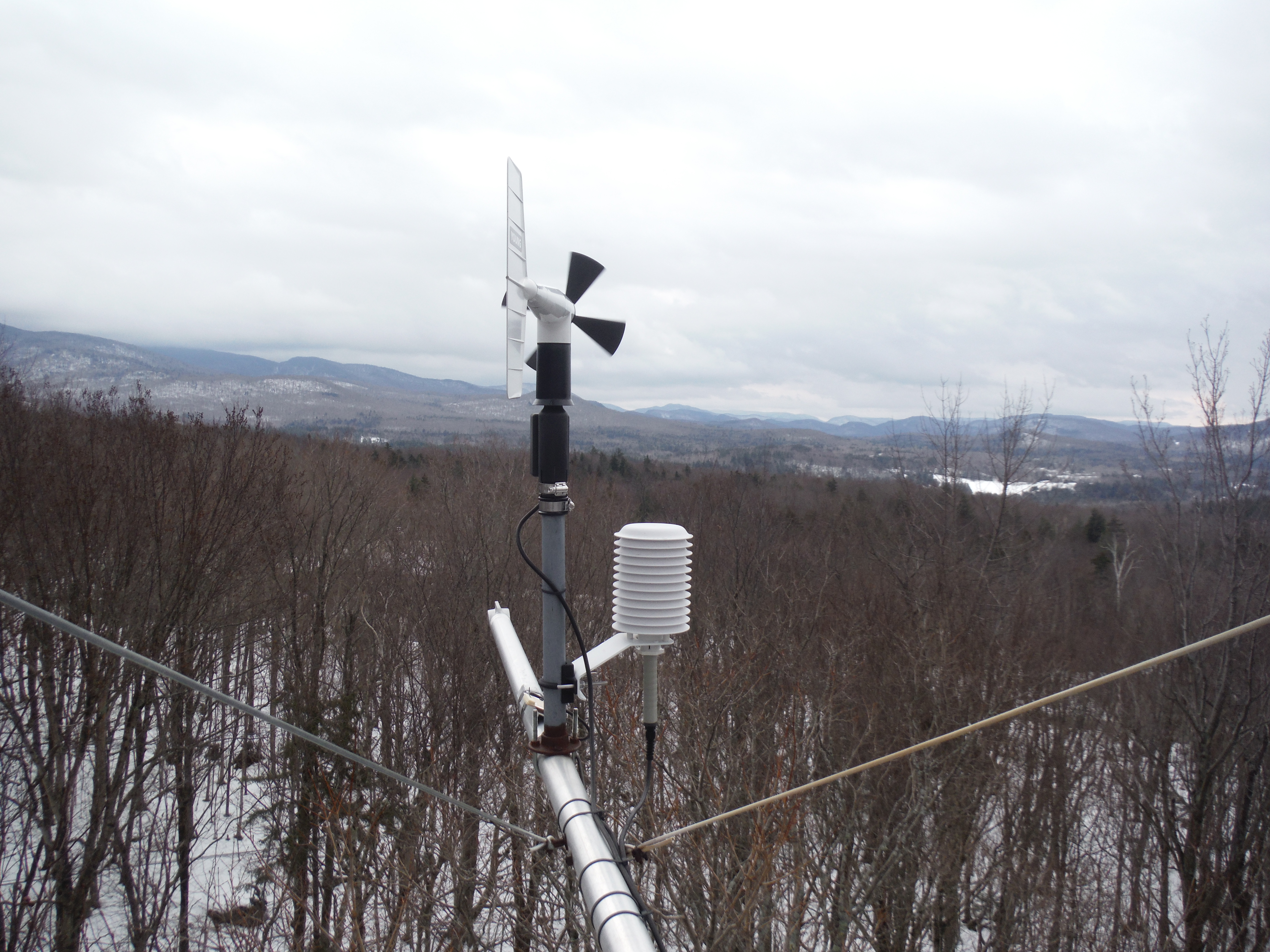
Meteorological and ozone data
Started: 1992-07-07Meteorology and ozone data collected at five heights: 0.5, 7.5, 12, 16, and 24 m. Continuous measurements averaged quarter-hourly; hourly and daily averages computed. Year-round measurements for meteorology and soil; April-October measurements of ozone.
Measurements
Started: 1992-07-07Measurements include: ambient air temperature, relative humidity, surface wetness, wind speed, direction and direction variance, PAR, total irradiance, and UV-B at 24 m, ozone concentration, soil temperature and snow depth.
CO2 flux and concentration measurements ended in September 2000.
Past Methods (No longer in use)
- CO2 analysis
Started: 1999-05-01
Ended: 1999-12-30CO2 concentration in air and analysis of CO2 flux using micrometeorological methods at top of canopy.
- CO2 flux
Started: 1999-05-01
Ended: 1999-12-30CO2 flux from soil using monthly soda-lime chamber method.
- Vegetation mapping
Started: 1999-05-01
Ended: 1999-12-30Mapping of vegetation within 100 meters of forest tower.
Started: 1992-07-07
Ended: 1999-08-01Ozone measurements ended in August 1999.
Started: 1992-07-07
Ended: 2000-07-01UV-B measurements ended in July 2000.
Started: 1992-07-07
Ended: 2001-07-13Instrumentation was removed from the 12 meter level on July 13, 2001.
Dataset Fields
Detailed documentation of the fields comprising the dataset, including the type of measurement, units where applicable, and any controlled vocabularies or code lists present in the data
Field Name Caption Description Additional Information AirTemp AirTemp AirTemp
Ratio Units: Airtemp05 Air temp at 5m Air temp at 5m
Ratio
Unit: celsuisAirtemp12 Air temp at 12m Air temp at 12m
Ratio
Unit: celsuisAirtemp16 Air temp at 16m Air temp at 16m
Ratio Units: Airtemp24 Air temp at 24m Air temp at 24m
Ratio
Unit: celsuisAirtemp75 Air temp at 7.5m Air temp at 7.5m
Ratio
Unit: celsuisDate/Time Date/Time Date/Time
DateTime Date/Time Format: YYYY-MM-DD hh:mm:ss doy Day of Year The day of the year of observation
Interval
Unit: nominalDay
Precision: 1horizws05 horiz wind speed at 5m horiz wind speed at 5m
Ratio
Unit: metersPerSecondhorizws12 horiz wind speed at 12m horiz wind speed at 12m
Ratio
Unit: metersPerSecondhorizws16 horiz wind speed at 16m horiz wind speed at 16m
Ratio
Unit: metersPerSecondhorizws24 horiz wind speed at 24m horiz wind speed at 24m
Ratio
Unit: metersPerSecondhorizws75 horiz wind speed at 7.5m horiz wind speed at 7.5m
Ratio
Unit: metersPerSecondLeafwet05 Leafwet at 5m Leafwet at 5m
Ratio
Unit: ohmLeafwet12 Leafwet at 12m Leafwet at 12m
Ratio
Unit: ohmLeafwet16 Leafwet at 16m Leafwet at 16m
Ratio
Unit: ohmLeafwet24 Leafwet at 24m Leafwet at 24m
Ratio
Unit: ohmLeafwet75 Leafwet a 7.5m Leafwet a 7.5m
Ratio
Unit: ohmmaxws05 max wind speed at 5m max wind speed at 5m
Ratio
Unit: metersPerSecondmaxws12 max wind speed at 12m max wind speed at 12m
Ratio
Unit: metersPerSecondmaxws16 max wind speed at 16m max wind speed at 16m
Ratio
Unit: metersPerSecondmaxws75 max wind speed at 7.5m max wind speed at 7.5m
Ratio
Unit: metersPerSecondmaxws24 max wind speed at 24m max wind speed at 24m
Ratio
Unit: metersPerSecondpar Photo. Active Radiation (PAR) Photo. Active Radiation (PAR)
Ratio
Unit: umolePerSecondPerMeterSquaredresulwd05 resul wind direction at 5m resul wind direction at 5m
Ratio
Unit: degreeresulwd12 resul wind direction at 12m resul wind direction at 12m
Ratio
Unit: degreeresulwd16 resul wind direction at 16m resul wind direction at 16m
Ratio
Unit: degreeresulwd24 resul wind direction at 24m resul wind direction at 24m
Ratio
Unit: degreeresulwd75 resul wind direction at 7.5m resul wind direction at 7.5m
Ratio
Unit: degreeresulws05 resul wind speed at 5m resul wind speed at 5m
Ratio
Unit: metersPerSecondresulws12 resul wind speed at 12m resul wind speed at 12m
Ratio
Unit: metersPerSecondresulws16 resul wind speed at 16m resul wind speed at 16m
Ratio
Unit: metersPerSecondresulws24 resul wind speed at 24m resul wind speed at 24m
Ratio
Unit: metersPerSecondresulws75 resul wind speed at 7.5m resul wind speed at 7.5m
Ratio
Unit: metersPerSecondRhumid05 Rel humidity at 5m Rel humidity at 5m
Ratio
Unit: percentRhumid12 R humidity at 12m R humidity at 12m
Ratio Units: percent Rhumid16 Rel humidity at 16m Rel humidity at 16m
Ratio Units: percent Rhumid24 Rel humidity at 24m Rel humidity at 24m
Ratio Units: percent Rhumid75 Rel humidity at 7.5m Rel humidity at 7.5m
Ratio Units: percent Sdevwd05 std dev wind direction at 5m std dev wind direction at 5m
Ratio
Unit: degreesdevwd12 std dev wind direction at 12m std dev wind direction at 12m
Ratio
Unit: degreesdevwd16 std dev wind direction at 16m std dev wind direction at 16m
Ratio
Unit: degreesdevwd24 std dev wind direction at 24m std dev wind direction at 24m
Ratio
Unit: degreeSdevwd75 std dev wind direction at 7.5m std dev wind direction at 7.5m
Ratio
Unit: degreeTime Time Time
DateTime Date/Time Format: totalrad total radiation total radiation
Ratio Units: kilowatt per square meter UVB Ultraviolet B Ultraviolet B
Interval Units: Sampling Equipment
Equipment and software used to collect data, including how that equipment was used.
No sampling equipment recorded for this dataset
Site Characteristics
The spatial extent of the dataset site coverage, and descriptions of the spatial extent and context for the data collection
- Site Description
Proctor Maple Research Center on the west slope of Mount Mansfield, with a west/southwest aspect on a 2% slope; forest canopy tower 71 ft. (22m) height. Surrounding forest is intermediate-aged northern hardwood, with Lyman-Marlow association soil type..
Dataset Notes
Notes describing any special conditions or considerations for understanding the quality and consistency of the data
Start Date End Date Note Date Entered 2025-03-19 00:00:00 2025-03-19 23:59:59 BP went to tower to fix LWS and temp/rh sensor wiring at 1030-11. Took purple ground wire off datalogger for LWS 3 and 4. Data is back to normal now. TEMP/RH sensor wires were moved to separate SE ports (L1 in H5L5, L2, in H/L6, L3 in H/L 7, L4 in H/L8). 2025-03-19 12:20:14 2025-03-11 00:00:00 2025-03-11 23:59:59 Internet restored on 3/11/25. L3 and L4 temp sensors misfiring. will return to troubleshoot on 3/13/25 2025-03-13 11:18:08 2024-08-27 00:00:00 2024-08-27 23:59:59 BP replaced temp RH sensors at all levels around 1130-1pm. New sensor wiring was run from L4 back to the datalogger. L3 wind vane propellor was missing, so a new one was installed. Internet cable was severed at road, so internet is has been down since Aug 8. New cable will be run in the coming weeks. 2024-08-28 11:46:57 2024-02-27 00:00:00 2024-02-27 23:59:59 BP went up to install new leaf wetness sensors, replace broken wind nose at L3, and troubleshoot bad Temp sensor at L4. New leaf sensors were installed with junction boxes to connect to the old wiring. L4 temp sensor blew off and wires were severed, needs a new unit ordered. 2024-03-14 17:49:52 2023-10-31 00:00:00 2023-10-31 23:59:59 BP painted the sensors but noticed l3 and 4 sensors were worn down to the gold circuits and need to be replaced. (Bruce from campbell sci recommended painting the sensors with a white latex paint to stabalize the numbers and also protect them overtime.) 2024-03-14 17:46:11 2023-10-16 00:00:00 2023-10-16 00:00:00 BP updated the program and swapped the green wire for the L1 wind vane to an open H11 and moved the associated white ground to the slot next to it. This finally fixed the looming wind data issues and now for the first time in years there is a fully set of wind speed and direction data for all 4 levels of the tower (Context: Wind vane on Level 1 has not been working for years and level 4 -now level3- has not been working since December.) 2024-03-14 17:04:24 2023-09-26 09:00:00 2023-09-26 10:00:00 BP went up and tried a new unit on Level1 but Level3’s WD did not change. I then disconnected Level1 completely and now Level2, 3, and 4 are all reading accurately with a full range. It appears to me that there is some interaction going on between the sensors where they effect each other – probably the grounds/excitations channels. 2024-03-14 17:45:00 2023-09-22 09:00:00 2023-09-22 10:00:00 NV and BP went up on 9/22 and tested out new sensors at level 1 to make sure they worked. We put a working sensor out at Level3 and attached a sensor at Level1 that was only producing speed data. When we got home it was apparent that the direction data at Level3 was no longer working in a full range like it was while we were up there watching the data come in. 2024-03-14 17:43:51 2023-09-12 09:00:00 2023-09-12 10:00:00 BP swapped to 2 excitation channels for wind data. This is when we started getting a full range of direction data for all the working sensors (Lev2 and Lev4 were working better now) 2024-03-14 17:42:52 2023-08-29 09:00:00 2023-08-29 10:00:00 BP replaced the wiring to Level1. went up there at 9am and cut a new length of wire. The WS and WD at level 1 began working for an hour or 2 again - same for Level3 (formelyL4). Later that day the wind data became stuck again. 2024-03-14 17:40:20 2023-08-22 00:00:00 2023-08-22 00:00:00 BP replaced both whole wind units on Level1 and Level3 and while up there both appeared to be producing data. Level3 appeared to pop out of the 26-29 degree range that it was stuck at previously. Data became stuck again later that day 2024-03-14 17:37:20 2023-08-01 00:00:00 2023-08-01 23:59:59 BP replaced wind sensor on level 1 and 3 and rewired sensor 1. Still having issues with WD data on both sensors. Also replaced temp/rh sensors on level 1, 2, and 5 with newly calibrated sensors. 2023-09-01 12:28:20 2023-05-10 00:00:00 2023-05-10 23:59:59 BP visited to check on leaf wetness sensor wiring, lack of data for level 1 wind sensor, pyr and quant SN. I found the level 1 wind sensor was labeled as unknown and was not wired to anything on the datalogger. I traced it back to the wind sensor and labeled it. I then wired it to datalogger. The leaf wetness red wires are in H and L 9 and 10. 1 red wire in 9H and 1 red in 10L. Black in VX2, White in ground, purple in ground. Noticed the windvane on level 3 was missing a propellor nose; replaced that. 2024-03-14 16:59:39 2022-12-20 00:00:00 2022-12-20 23:59:59 BP replaced the RH/Temp sensor 3 EE-181L (201516000344b9). Old one came loose and is missing. Found the wire dangling without a sensor on it. 2022-12-20 18:22:44 2022-12-13 00:00:00 2022-12-13 23:59:59 BP and HM went up to replace broken wind vane at level 3. Nose was broken. Replaced with whole new unit. Data logger turned off at 931am and back on at 1036am. Temp/RH sensor at level 3 was missing and the cord was dangling from unit. New unit will be installed next week. 2022-12-14 09:57:15 2022-06-21 00:00:00 2022-06-21 23:59:59 AB visited. The weather was sunny, warm with a slight breeze. The leaf wetness was not reading correctly in the data. Using the loggernet program, AB created a wiring diagram for the leaf wetness sensors. Datalogger turned off at 912am, leaf sensors rewired, datalogger turned on at 917am. 2022-09-19 10:00:17 2022-06-14 00:00:00 2022-06-14 23:59:59 AB visited. Conditions were sunny, warm and there was a slight breeze. The temp sensors were still not reading correctly and are compatible with the CR3000 datalogger. On this visit, the multiplexer was removed as it seemed to be obsolete according to research. The datalogger was turned off at 10:45, rewired and turned on at 11:13. 2022-09-19 09:56:25 2022-06-07 00:00:00 2022-06-07 23:59:59 AB visited to rewire. Conditions were windy, warm and overcast. Datalogger turned off at 12:17pm. EE181 sensors rewired. datalogger turned back on at 12:20pm. 2022-09-19 09:53:53 2022-05-24 00:00:00 2022-05-24 23:59:59 AB visited. datalogger was rewired. pyranometer and quantum sensors were checked. 2022-09-19 09:52:25 2022-05-17 00:00:00 2022-05-17 23:59:59 AB visited. Conditions were rainy and windy. The temperature was between 50 and 60 deg. F. Datalogger was turned off at 11:10am. All four temp/RH sensors were replaced and updated from HMC45 to EE181 sensors and wires were redone. The datalogger was turned back on at 4:30pm. 2022-09-19 09:46:49 2021-11-30 00:00:00 2021-11-30 23:59:59 AB and NC went to FCT to replace uncalibrated sensor with calibrated one. Power had been out in the shed so we turned on power in fuse box. Battery that connects to the computer, data logger, and light seemed to be dead. We were able to move essential items to the battery bypass outlets, and AB will check on the battery charge next Tuesday. Sensor replacement was successful and Temp/rh 2 was reading data at 1115 EST. 2021-12-01 15:16:10 2021-11-16 00:00:00 2021-11-16 23:59:59 AB and NC went to FCT to install an uncalibrated Temp/RH 2. We tested the function of the sensor by leaving it in the warm shed for an hour or so. Once confirmed that the sensor was able to read the data, we installed it on the second level of the FCT. Power went out shortly in the shed while we were there-- we may have shorted the circuit by plugging in a lamp. We saw data come in after the installation that seemed accurate. We will install a calibrated Temp/RH later this year. Sensor was tested indoors between 930 AM DST - 10:30 DST. Then the sensor was deployed officially at 12:00 PM DST on 11/16/2021. 2021-11-17 09:37:03 2021-11-05 00:00:00 0000-00-00 00:00:00 JT and NC went to MMW on 11/05/2021 to check on the battery voltage. Time off at NC's last visit showed that the battery was at 3.94 V. JT and NC replaced the battery with a new one and covered the battery in a backpack cover. This should keep moisture out of the battery. The voltage read at 12.34 V when we left at the battery and datalogger terminals. JD attempted to remote into the site but had troubles. Eventually was able to get in but it was extremely slow.The rain gage has also fallen over, we will need to bring materials to rebuild a new base for next time. 2021-11-04 15:20:04 2021-11-04 00:00:00 0000-00-00 00:00:00 JT and NC went to FCT on 10/29/2021 to change out the temp/rh at levels 1,3, and 4. Additionally the pyranometer and the quantum were replaced. The quantum was a long one and the pyranometer use was short cabled. There were no sounds coming from any of the RM youngs. The temp/rh at the second level will be replaced shortly. 2021-11-04 13:27:05 2021-10-18 00:00:00 2021-10-18 23:59:59 JT noticed that the Py and Qu which were due for calibration in 2020 were not swapped out. This was likely due to Covid restricting our ability to get calibrated sensors. This will be swapped out in October of 2021. The sensors were out of calibration from 8/28/2020 to 10/29/2021. New Qu and Py sensors were deployed on 10/29/2021. 2021-10-18 16:10:14 2021-09-28 00:00:00 2021-09-28 23:59:59 AB and NC tensioned cables. Checked cables following the directions. Started with the cable point in front of the shed door as #1 and worked counter clockwise. (1-4). checked 1 and 2, then 2 and 3, then 3 and 4, then finally 4 and 1. Adjusted #1 top cable which was above 700. #2 bottom cable was below 600, and middle was below 600 (corrected). #3 bottom cable was low, top was low at first and high on the second check (corrected). #4 bottom cable was low on the first check and high on the second (corrected). External battery that computer is plugged in to was off. May have been an electrical storm that tripped it. Turned it back on as well as the computer and re started loggernet at 12:22pm. 2021-09-28 15:21:29 2021-09-07 00:00:00 2021-09-07 23:59:59 JT and AB received the datalogger back from Campbell Sci on September 3rd, 2021. Only a couple weeks worth of data could be saved from the datalogger (08/05/2021 @13:45 to 08/10/2021 @10:45). We followed a wiring diagram that matched the previous setup while the logger was working. The notes for the wiring diagram can be found at I:\Administration\Met&AQ Monitoring Operations\ForestCanopyTower (Filename 20210810_FCT_Wiring). The program that is on the data logger is stored in I:\Administration\Met&AQ Monitoring Operations\Datalogger_Programs\Tower (Tower_CR3000-revCW_08-29-2018). None of the RS232 cables in the shed worked so we ultimately decided to use a USB to CSIO cable set u to connect the computer to the datalogger. It's possible the RS232 port is fried. The FCT officially went back on at 3:10 EDT but the computer is set at EST. The lowest wind monitor and the second level temp/rh was not reconnected. Lowest wind monitor is too low to the ground and the 2nd level temp/rh needs to be replaced entirely. 2021-09-08 15:22:43 2021-08-12 00:00:00 2021-08-12 23:59:59 The FCT datalogger stopped connecting the the computer on 06/21/2021 after a lightning storm took out a lot of the equipment at the AQ site as well. Through further inspection we found that the 5V terminal on the datalogger was damaged. Because of this the datalogger needed to be sent to campbell sci for repair. The datalogger was pulled offline at 11:50 AM. We are unsure if we will be able to recover the data from 06/21/2021 to 8/10/2021. We will need campbell to confirm if this data can be saved. The FCT datalogger will be offline until returned from campbell. The wiring for the datalogger is all recorded within the FCT idrive folder on I:\Administration\Met&AQ Monitoring Operations\ForestCanopyTower\20210810_FCT_Visit. 2021-08-12 09:47:24 2020-11-17 00:00:00 2020-11-17 23:59:59 JT and AB went out to check the wire tensions before the winter hit. We adjusted all the wires for the NW corner and the SE corner. Generally, the wires were too tight. We also adjusted the bottom wire of the NE corner as it was too tight. This resulted in the opposite corner (SW) having a bottom wire that was set at around 740. With all the wires within the appropriate range of 600-700, we left the SW corners bottom wire at 740. To adjust this corner will require some digging as the tenioner is buried. All lock nuts were lubricated and tightened. JT also updated the computer but it resulted in the computer getting stuck in a restart phase. It is likely that low temps were what caused the computer to lag. JT bought a new heater (as all the other ones didn't seem to work) and turned it on. 2020-11-17 15:35:13 2020-08-05 00:00:00 2020-08-05 23:59:59 JT and AB visited site to perform regular maintenance. Swapped out temp/RH probes (E2820002,Z2220083, ) with new temp sensors (A3510090, Z1050094, F2450241). These sensors were at locations 1,3, and 4. We pulled all of the cabling for temp sensor at lvl 2. The mount for this sensor is a 6 wire cable. Clear/transparent in shield between H1 and L2 on AM416 relay multiplier. Black is in Ground (G) on the fourth terminal. Red is in 12 volt on 4th terminal. Yellow is in H1 on the AM416. Blue is in H2 on AM416. White is in L2, jumper cable from L2 to L1 on AM416. The logger was turned off at 0914 and turned back on at 1130. The 4th temp sensor had some strange readings up until 1230 PM. 2020-08-05 12:36:02 2020-04-28 00:00:00 2020-04-28 23:59:59 04282020-JT inspected the FCT tempRH probe at 7.5m to find the probe head connector had corrosion and a missing pin. This may have been what lead to the 7.5m temprh data being incorrect even after switching out a calibrated temprh(Y2850113). The probe was removed from the connector to prevent damage and the connector was left on the tower and covered up using tape and a glove to prevent. The cables were not pulled from the datalogger as I ran out of time and could not figure out which wires belonged to the probe. A new tempRH set up will be deployed. Until then the 7.5tempRH data will not be collected. Off at 1032 EST and on at 1111 EST. 2020-04-28 11:13:05 2020-03-10 00:00:00 2020-03-10 23:59:59 JT replaced 7.5 m temp/rh (V4550004) with new probe (Y2850113) probe because of issues that were pointed out in the note on 03/05/2020. I noticed that the probe looked like it had dropped a little from the shield and then as I took it out of the connection I noticed that the bottom of the port had some blue substance coming out of it. Likley due to corrosion. Upon further inspection I saw that there was a crack near the base of the probe. This is likely where water got in. The logger was turned off at 9:28 AM EDT and turned back on at 10:00 AM EDT. 2020-03-10 12:33:44 2020-03-05 00:00:00 2020-03-05 23:59:59 Issues with the 7.5 m relhumid readings. They have been well over a hundred for odd periods of time. on 03/02/2020 at 0915 AM the reading was beginning to creep over 100 then shot up extremely high at 1:30 PM (~500) then went to zero and came back into the 500s at 2:45PM. The values then began to drop and went back to normal readings at 6:45PM. This also occurred between 03/04/2020 at 5:15 PM and 03/05/2020 at 04:45 AM. 2020-03-05 08:09:41 2020-03-03 00:00:00 2020-03-03 23:59:59 At 12:59 PM, MS went to the tower to check on the highest temp/rh probe (75') because it was reading high relhumidity for a couple hours on 03/02/2020. MS Just briefly removed the sensor to check for any damage and there was none so it was reinstalled. Unsure about the large spike in humidity. 2020-03-03 14:05:23 2019-09-24 00:00:00 2019-09-24 23:59:59 On Tuesday, September 24th, 2019 JT and FEMC Americorp Jake Van Deursen went out to tension the canopy tower cables. Each corner of the tower required at least one of the cables to be tensioned to the proper range of 600-700 lbs. All cables were tensioned properly and the locknuts were locked into place to prevent movement. 2019-09-25 08:07:49 2019-05-02 00:00:00 2019-05-02 23:59:59 On Thursday May 2nd, 2019 at 9:30 AM JT, MF, and MP went out to tension the canopy tower wires. All wires were checked. The pair of wires on the south facing side were all within the desired tension range (650 - 750lbs). On the north facing side the middle wires were tensioned. The top and bottom wires on the north side did not require tensioning. The tensiometers are stored at the tower shelter. The are two in wooden cases. It is important that they are not stored while wet. When tensioning, dry them off and leave out to dry before putting them away in cases. The wires should be checked twice a year, once during the spring and once during the fall. 2019-05-03 14:41:14 2019-04-23 12:06:00 2019-04-23 14:20:00 JT and MF visited the tower on 4/23/19. Power to logger off at 1206 EDT. Installed the following temp/rh probes at the following heights (A3710009 at lvl 1, V4550004 at lvl 2, E2820002 at lvl 3, and Z2220083 at lvl 4). The temp/rh sensors we removed from the site were A4810112, W2340053, Z36610172, and T0330026. We also replaced bearings of RM young wind monitor anemometers at levels 3 and 4 (only flange bearing was replaced). Note that each anemometer requires two bearings at front and back. Power on at 2:21 PM. Anemometer at level 3 was a little crooked. We used a piece of ziptie to wedge into the support arm to straighten out the arm. Consider bringing a longer term solution next visit (metal?). 2019-04-23 12:10:43 2019-03-19 00:00:00 2019-03-19 23:59:59 Removed UPS from system as battery was dead. Was unable to remove battery from UPS due to swelling of battery and a wee piece of foam in the enclosure. Was later able to remove it by prying around with a flathead screwdriver. 2019-03-19 14:25:59 2019-03-06 00:00:00 2019-03-06 23:59:59 Ali and Mike re-aligned 16m support arm holding wind bird and temp/rh probe. The hose clamp holding it down had loosened and the added weight of the temp/rh unit caused it to tilt to the right. We tightened this hose clamp and added an additional one forming an X and is holding tight. Work completed around 1430 EST. 2019-03-11 10:51:11 2019-02-26 11:20:00 2019-02-26 11:25:00 Visited tower to see why PC was not updating and found the computer off. Booted it up and collected data successfully. While there I noticed the pyranometer and quantum mast was not upright, pointing about 45 degrees off vertical towards the north. I righted the mast and tightened the u-bolts that had come loose. This was done at 11:20 AM. Looking at the data, it is not obvious when the mast tipped over so QAQC data has been null'ed out from the new extension cable install on 2018-10-30 15:25 - now. 2019-02-26 14:16:03 2018-12-04 10:30:00 2018-12-04 10:35:00 Power went off at PMRC over the weekend (on 12/2?) - rebooted tower PC at 10:30 on 12/4 and collected data. 2018-12-04 11:47:38 2018-10-30 13:45:00 2018-10-30 15:25:00 Replaced extension cable for pyranometer. Power to logger off from 1345 - 1525 EDT. Now getting good pyranometer data. 2018-10-30 15:28:03 2018-09-11 00:00:00 2018-09-11 23:59:59 Removed pyranometer to troubleshoot whether it is a programming error, hardware error, or both that we are receiving zero (or very close to zero) values. logger off: 9/11/2018 1250 EDT logger on with pyranometer and millivolt adapter removed: 1318 EDT Brought pyran and millivolt adapter back to Spear Street to troubleshoot. Volt meter at PMRC was out of battery power. When reconnecting to CR3000, Millivolt green > 7H, blue > 7L, jumper from 7L to adjacent ground. 2018-09-11 17:01:04 2018-08-29 12:50:00 2018-08-29 13:00:00 Updated program with new logic to compute SlrkJ. Math, resources, and program at I:\Administration\Met&AQ; Monitoring Operations\PMRC Tower\20180829 Program 2018-08-29 13:04:01 2018-08-28 00:00:00 2018-08-28 23:59:59 8/28/18 MF and JT swapped out the Pyranometer and Quantum on the Forest Canopy Tower. The old Pyranometer (SN:PY89044) was swapped with a new one, SN:PY59197 and the old Quantum (SN:Q40364) was swapped with a new one, SN:Q3943. The power was shut off at ~1:30PM EDT and Turned back on at ~2:30PM EDT. Note that the Quantum and Pyranometer were both short cables that connect to extenders at the top which are housed within short PVC segments. The only issue we encountered was figuring out the new multiplier for the Pyranometer because the model that came back was a LI-200X while the original was a LI-200R. The suspected issue is that the 200R uses a milliivolt adapter that the 200X model does not need. 2018-08-29 09:36:32 2018-07-24 11:45:00 2018-07-24 11:55:00 MF replaced 24m HMP45AC S/N V550002 with S/N T0330026 due to faulty RH readings often out of range when RH > 80% (sometimes reading upwards of 120%). Power off to logger at 1145 EDT, back on at 1155 EDT and data looks good. 2018-07-24 11:59:27 2018-04-09 00:00:00 2018-04-09 23:59:59 Data from 04/03/2014 10:15 AM to 07/07/2016 1300 were appended to the dataset. The dataset within this date interval was reformatted using a python script created by JT. Through further inspection of the data it was noted that there were little chunks of data missing here and there. Additionally some data files were discovered to have their DOY being wrong which made that data unusable. The DOYs were confirmed wrong because they did not match the dates within the file names or the data log provided by MP. The DOYs did not match the temperatures that were showing up in the data. Through reviewing the datalog it's hypothesized that power outages may have caused the weird jumps in DOY but there is not certain answer to the problem. The data that was deemed to be missing are (10/01/2014-12/17/2014), (01/01/2015-03/25/2015), (08/07/2015-07/21/2016), (07/18/2015-09/30/2015), (05/31/2015-06/22/2015), (08/27/2015-01/07/2015), (01/10/2016-01/13/2016),(02/14/2016-03/15/2016),(06/19/2016-07/01/2016), (07/07/2016-08/01/2016). An additional issue noted was that when time is 0 the date should be plus one day. The script to reformat the data does not account for this, therefore, the dates were modified in excel by simply adding a day to all the dates were time was 0. This was done to have midnight be the first start time for all dates and not 12:15 AM. 2018-04-09 11:44:43 2018-02-15 12:00:00 2018-02-15 14:59:59 Beginning at 1:00 pm all 4 temperature probes on the canopy tower (E2820002, Z2220083, A3710009, V4550004) were replaced with 4 calibrated temp probes (Z3610172, V455002, W2340053, A4810112). The second temp probe heading up has a heat shield that was difficult to loosen and tighten. Consider swapping new heat shield in the future. Canopy towers computer switched with another one to allow for real-time data capture and transmission. Currently, the computer does not transfer live data and needs to be manually transferred. Live data feed coming soon. 2018-02-15 15:57:50 2016-07-25 10:00:00 2016-07-25 12:00:00 Replaced tower pyranometer, quantum and temperature/relative humidity sensors from canopy tower top level; fixed arm at 3rd level; replaced CR 21X with CR-1000 but programming is not complete 2016-08-02 00:00:00 2013-10-30 14:15:00 2013-11-15 14:45:00 Missing Data 2014-10-16 00:00:00 2013-10-30 14:00:00 2013-11-13 15:15:00 Missing Data 2014-10-16 00:00:00 2013-09-29 02:15:00 2013-09-30 02:15:00 Missing Data 2014-10-16 00:00:00 2013-09-28 02:15:00 2013-09-29 02:15:00 Missing Data 2014-10-16 00:00:00 2013-09-27 02:15:00 2013-09-28 02:15:00 Missing Data 2014-10-16 00:00:00 2013-09-26 02:15:00 2013-09-27 02:15:00 Missing Data 2014-10-16 00:00:00 2013-09-25 02:15:00 2013-09-26 02:15:00 Missing Data 2014-10-16 00:00:00 2013-09-24 02:15:00 2013-09-25 02:15:00 Missing Data 2014-10-16 00:00:00 2013-08-05 14:30:00 2013-08-09 14:45:00 Missing Data 2014-10-16 00:00:00 2013-07-19 13:15:00 2013-07-22 13:15:00 Missing Data 2014-10-16 00:00:00 2013-06-07 10:45:00 2013-06-18 14:00:00 Missing Data 2014-10-16 00:00:00 2013-05-22 07:00:00 2013-06-06 14:30:00 Missing Data 2014-10-16 00:00:00 2013-02-19 08:00:00 2013-02-20 08:30:00 Missing Data 2014-10-16 00:00:00 2012-12-19 08:00:00 2012-12-21 15:15:00 Missing Data 2014-10-16 00:00:00 2012-10-29 09:15:00 2012-10-29 13:45:00 missing records 2014-10-16 00:00:00 2012-10-29 09:00:00 2012-10-31 14:00:00 Missing Data 2014-10-16 00:00:00 2012-10-01 23:45:00 2012-10-03 00:15:00 Missing Data 2014-10-16 00:00:00 2012-07-09 08:00:00 2012-07-16 12:00:00 Missing Data 2014-10-16 00:00:00 2012-06-06 08:00:00 2012-06-11 10:30:00 Missing Data 2014-10-16 00:00:00 2011-12-27 09:00:00 2012-01-02 09:30:00 Missing Data 2014-10-16 00:00:00 2011-09-09 08:00:00 2011-09-12 08:30:00 Missing Data 2014-10-16 00:00:00 2011-08-08 08:15:00 2011-08-24 08:00:00 Missing Data 2014-10-16 00:00:00 2011-04-16 08:00:00 2011-07-22 14:45:00 Missing Data 2014-10-16 00:00:00 2010-12-16 07:45:00 2011-01-01 08:30:00 Missing Data 2014-10-16 00:00:00 2010-12-01 07:45:00 2010-12-06 16:45:00 Missing Data 2014-10-16 00:00:00 2010-11-12 08:00:00 2010-11-13 01:15:00 Missing Data 2014-10-16 00:00:00 2010-09-21 07:45:00 2010-09-24 13:30:00 Missing Data 2014-10-16 00:00:00 2010-08-02 07:45:00 2010-08-11 01:45:00 Missing Data 2014-10-16 00:00:00 2010-04-28 08:00:00 2010-04-28 15:45:00 Missing Data 2014-10-16 00:00:00 2010-03-17 08:00:00 2010-03-17 14:00:00 Missing Data 2014-10-16 00:00:00 2010-01-25 07:45:00 2010-01-29 15:45:00 Missing Data 2014-10-16 00:00:00 2010-01-08 08:00:00 2010-01-21 08:15:00 Missing Data 2014-10-16 00:00:00 2009-11-27 07:45:00 2009-12-04 15:45:00 Missing Data 2014-10-16 00:00:00 2009-11-06 08:00:00 2009-11-09 12:00:00 Missing Data 2014-10-16 00:00:00 2009-04-20 07:45:00 2009-04-23 12:30:00 Missing Data 2014-10-16 00:00:00 2008-11-05 07:45:00 2008-11-07 12:00:00 Missing Data 2014-10-16 00:00:00 2008-06-29 07:45:00 2008-06-30 12:45:00 Missing Data 2014-10-16 00:00:00 2008-06-05 07:45:00 2008-06-12 08:15:00 Missing Data 2014-10-16 00:00:00 2008-03-08 07:45:00 2008-03-11 11:15:00 Missing Data 2014-10-16 00:00:00 2007-12-24 07:45:00 2007-12-26 03:15:00 Missing Data 2014-10-16 00:00:00 2007-07-24 08:00:00 2007-07-26 02:45:00 missing data 2014-10-16 00:00:00 2007-07-06 07:45:00 2007-07-30 11:00:00 Missing Data 2014-10-16 00:00:00 2007-05-18 07:45:00 2007-05-25 08:15:00 Missing Data 2014-10-16 00:00:00 2007-01-09 08:00:00 2007-01-11 03:15:00 Missing Data 2014-10-16 00:00:00 2007-01-09 07:45:00 2007-01-11 03:45:00 Missing Data 2014-10-16 00:00:00 2006-12-07 09:30:00 2006-12-11 08:15:00 Missing Data 2014-10-16 00:00:00 2006-11-29 08:00:00 2006-11-29 13:30:00 Missing Data 2014-10-16 00:00:00 2006-11-22 14:00:00 2006-11-27 09:45:00 Missing Data 2014-10-16 00:00:00 2004-12-07 17:00:00 2006-11-07 13:45:00 Missing Data 2014-10-16 00:00:00 2004-02-02 08:15:00 2004-02-02 17:30:00 Missing Data 2014-10-16 00:00:00 2004-01-23 08:15:00 2004-01-24 22:15:00 Missing Data 2014-10-16 00:00:00 2004-01-23 08:00:00 2004-01-24 22:45:00 Missing Data 2014-10-16 00:00:00 2003-11-14 08:15:00 2003-11-14 12:34:00 Missing Data 2014-10-16 00:00:00 2003-10-15 08:00:00 2003-10-25 20:15:00 Missing Data 2014-10-16 00:00:00 2003-09-21 20:00:00 2003-11-24 11:30:00 Anemometer wind speed sensor at 17m damaged 2014-10-16 00:00:00 2003-09-21 20:00:00 2003-10-29 12:15:00 Anemometer wind direction sensor at 17m damaged 2014-10-16 00:00:00 2003-09-19 08:00:00 2003-09-21 20:30:00 Missing Data 2014-10-16 00:00:00 2003-06-30 08:15:00 2003-07-02 18:30:00 Data collection failure, missing data 2014-10-16 00:00:00 2003-06-30 08:00:00 2003-07-03 19:00:00 Missing Data 2014-10-16 00:00:00 2003-06-13 22:00:00 2003-08-15 12:45:00 Anemometer at 17m damaged, wire eventually repaired 2014-10-16 00:00:00 2003-05-20 13:30:00 2003-07-09 12:45:00 Air temp and humidity sensors at all levels taken offline for calibration 2014-10-16 00:00:00 2003-03-21 08:15:00 2003-03-22 21:00:00 Missing Data 2014-10-16 00:00:00 2003-03-21 08:00:00 2003-03-22 21:30:00 Missing Data 2014-10-16 00:00:00 2003-02-04 09:30:00 2003-03-18 14:30:00 Anemometer at 17m damaged 2014-10-16 00:00:00 2002-07-18 13:45:00 2002-07-20 20:45:00 Missing Data 2014-10-16 00:00:00 2001-09-19 00:15:00 2001-09-22 17:45:00 Missing Data 2014-10-16 00:00:00 2001-09-07 00:00:00 2001-09-09 20:30:00 Missing Data 2014-10-16 00:00:00 2001-08-31 00:00:00 2001-09-02 21:00:00 Missing Data 2014-10-16 00:00:00 2000-10-06 07:00:00 2000-10-16 07:15:00 Missing Data 2014-10-16 00:00:00 1999-02-03 08:00:00 1999-02-09 14:45:00 Missing Data 2014-10-16 00:00:00 1998-02-05 07:45:00 1998-02-06 23:00:00 Missing Data 2014-10-16 00:00:00 1997-07-24 15:45:00 1997-07-25 22:45:00 Missing Data 2014-10-16 00:00:00 1997-04-03 11:15:00 1997-04-06 00:30:00 Missing Data 2014-10-16 00:00:00 1996-11-26 15:45:00 1996-11-27 18:45:00 Missing Data 2014-10-16 00:00:00 1996-04-23 13:00:00 1996-04-29 20:45:00 Missing Data 2014-10-16 00:00:00 1995-11-24 11:00:00 1995-11-26 23:45:00 Missing Data 2014-10-16 00:00:00 1995-09-19 14:15:00 1995-09-21 23:45:00 Missing Data 2014-10-16 00:00:00 1995-07-19 10:45:00 1995-07-20 22:30:00 Missing Data 2014-10-16 00:00:00 1995-06-13 14:45:00 1995-06-14 21:30:00 Missing Data 2014-10-16 00:00:00 1995-02-22 14:45:00 1995-02-24 01:00:00 Missing Data 2014-10-16 00:00:00 1994-09-02 13:45:00 1994-09-04 22:45:00 Missing Data 2014-10-16 00:00:00 1994-07-30 16:45:00 1994-08-01 00:15:00 Missing Data 2014-10-16 00:00:00