
Details and Metadata
Printer-friendly version View XML version Download Ecological Metadata Language file
Methods
The methods followed in the creation of the dataset, including description of field, laboratory and processing steps, and quality control procedures
Current Methods
Started: 1996-07-29The station provides near real-time monitoring for meteorological variables including wind speed and direction, air and water temperature, relative humidity, barometric pressure, and total solar irradiance. Data are automatically downloaded via radio frequency modem on an hourly basis with 15 minute average records collected and stored during each downloading cycle. Data are available in an hourly and daily format.
Dataset Fields
Detailed documentation of the fields comprising the dataset, including the type of measurement, units where applicable, and any controlled vocabularies or code lists present in the data
Field Name Caption Description Additional Information RECORDTIME Date/Time Time and date when measurments were recorded
DateTime Date/Time Format: YYYY-MM-DD hh:mm:ss SAMPLEYEAR Sample Year Sample year as recorded by datalogger
DateTime
Unit: nominalYear
Date/Time Format: YYYYSAMPLEMONTH Sample Month Sample month of data collection
DateTime Date/Time Format: MM Sample_Day Sample Day Day of data collection
Interval Units:
Precision: 1SAMPLETIME Sample Time Sample time as recorded by datalogger
DateTime Date/Time Format: hhmm 38m_AIRTEMP 38m Air Temperature Measured air temperature at 38 meters above mean sea level
Ratio
Unit: celsuis
Precision: 0.00138m_RELHUMID 38m Relative Humdity Relative humidity at 38 meters above mean sea level
Ratio Units: dimensionless
Precision: 0.0132m_BAROPRESS 32m Barometric Pressure Measured barometric pressure at 32 meters above mean sea level
Ratio Units: millibar
Precision: 1PYRANOM Pyranometer Reading Pyranometer reading of solar intensity
Interval
Unit: wattsPerMeterSquared
Precision: 0.01WATERTEMP Water Temperature Measured water temperature
Interval
Unit: celsuis
Precision: 0.01NRG_38m_MAX_WINDSPEED 38m NRG Maximum Wind Speed Highest recorded wind speed using NRG equipment at 38 meters above mean sea level
Ratio
Unit: metersPerSecond
Precision: 0.001NRG_38m_TIME_MAX_WINDSPEED 38m NRG Time Maximum Wind Speed Time of maximum wind speed at 38 meters above mean sea level using NRG equipment
DateTime
Unit: nominalHour
Date/Time Format: hhmmNRG_38m_MEAN_WIND_DIRECTION 38m NRG Mean Wind Direction Average wind direction at 38 meters above mean sea level using NRG equipment
Ratio
Unit: degree
Precision: 0.1PRECIP Precipitation Measured amount of precipitation
Ratio
Unit: millimeter
Precision: 0.01NRG_38m_MEAN_HORIZONTAL_WINDSPEED 38m NRG Mean Horizontal Wind Speed Mean horizontal wind speed using NRG equipment
Ratio
Unit: metersPerSecond
Precision: 0.00132m_AIRTEMP 32m Air Temperature Air Temperature at 32 meters above mean sea level
Interval
Unit: celsuis
Precision: 0.001NRG_38m_STDDEV_WIND_DIRECTION 38m NRG Wind Direction Standard Deviation Standard deviation of wind direction at 38 meters above mean sea level using NRG equipment
Ratio
Unit: degree
Precision: 0.001NRG_38m_MEAN_RESULTANT_WINDSPEED 38m NRG Mean Resultant Wind Speed Mean resultant wind speed using NRG eqipment
Ratio
Unit: metersPerSecond
Precision: 0.00132m_RELHUMID 32m Relative Humidity Relative humidity at 32 meters above mean sea level
Ratio Units: dimensionless
Precision: 0.01Met1_38m_MAX_WINDSPEED 38m Met1 Maximum Wind Speed Maximum wind speed at 38 meters above mean sea level using Met1 equipment. The Met1 sensor data became unreliable after 14:00 EST August 25, 2009 and have been removed.
Ratio
Unit: metersPerSecond
Precision: 0.001Met1_38m_TIME_MAX_WINDSPEED 38m Met1 Time Maximum Wind Speed Time of maximum wind speed at 38 meters above mean sea level using Met1 equipment. The Met1 sensor data became unreliable after 14:00 EST August 25, 2009 and have been removed.
DateTime Date/Time Format: hhmm Met1_38m_MEAN_WIND_DIRECTION 38m Met1 Mean Wind Direction Average wind direction at 38 meters above mean sea level using Met1 equipment. The Met1 sensor data became unreliable after 14:00 EST August 25, 2009 and have been removed.
Ratio
Unit: degree
Precision: 0.001Met1_38m_STDDEV_WIND_DIRECTION 38m Met1 Wind Direction Standard Deviation Standard deviation of wind direction at 38 meters above mean sea level using Met 1 equipment. The Met1 sensor data became unreliable after 14:00 EST August 25, 2009 and have been removed.
Ratio
Unit: degree
Precision: 0.001Met1_38m_MEAN_HORIZONTAL_WINDSPEED 38m Met1 Mean Horizontal Wind Speed Average horizontal wind speed at 38 meters using Met 1 equipment. The Met1 sensor data became unreliable after 14:00 EST August 25, 2009 and have been removed.
Ratio
Unit: metersPerSecond
Precision: 0.001Met1_38m_MEAN_RESULTANT_WINDSPEED 38m Met1 Mean Resultant Wind Speed Average resultant wind speed using Met1 equipment. The Met1 sensor data became unreliable after 14:00 EST August 25, 2009 and have been removed.
Ratio
Unit: metersPerSecond
Precision: 0.001Sampling Equipment
Equipment and software used to collect data, including how that equipment was used.
Current Equipment
Data logger, meteorological sensors, radio fr
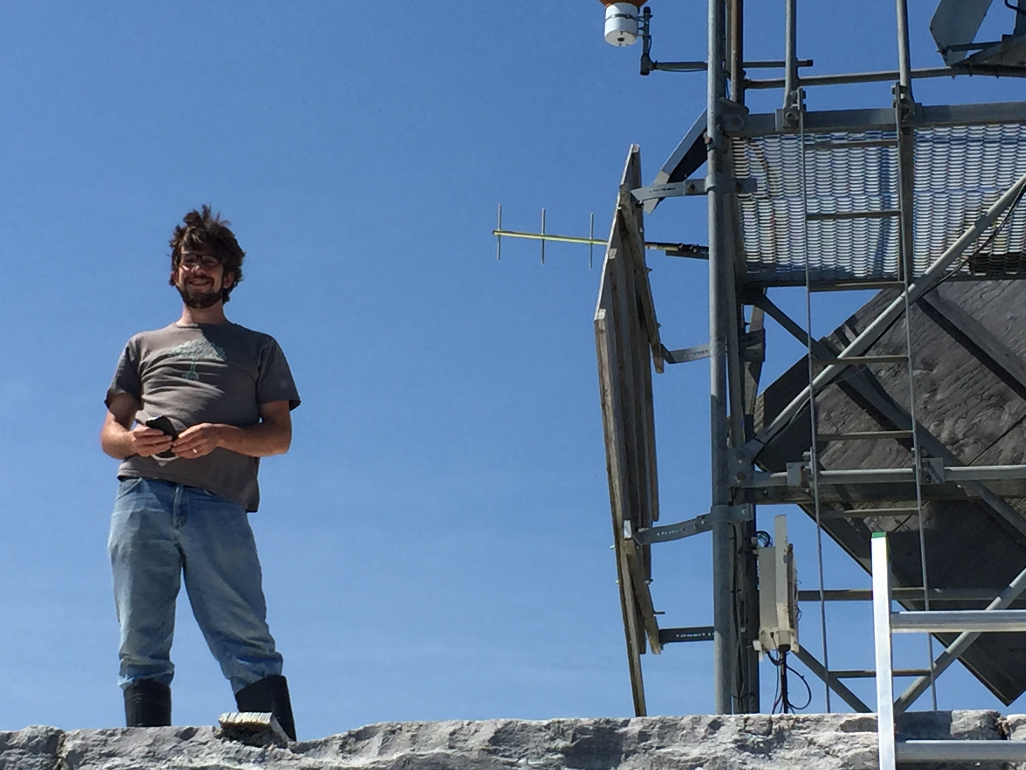
Started: 1996-07-29Campbell Scientific CR 10X datalogger with meteorological sensors and radio frequency modem.
Past Sampling Equipment (No longer in use)
Anemometer
Started: 1996-07-29
Ended: 1999-12-31R.M. Young anemometer used at heigh of 38 meters from 1996 to 2000
Anemometer
Started: 2000-01-01
Ended: 2003-12-31NRG Systems anemometer placed at height of 38 meters
Anemometer
Started: 2003-01-01
Ended: 2005-12-31Met One Instruments anemometer used at height of 38 meters for several years from 2003 to 2005
Site Characteristics
The spatial extent of the dataset site coverage, and descriptions of the spatial extent and context for the data collection
- Site Description
The site is located at latitude 44.5550985, longitude -73.3289647, WGS 1984 coordinate system
- Site Description
Colchester Reef on the US Coast Guard Station navigational warning light tower, on the lake.
Dataset Notes
Notes describing any special conditions or considerations for understanding the quality and consistency of the data
Start Date End Date Note Date Entered 2024-06-07 00:00:00 2024-06-07 23:59:59 *A new dataset was created for the new Fondriest weather station at CR - this dataset can be found here: https://www.uvm.edu/femc/data/archive/project/colchester-reef-meteorological-monitoring/dataset/colchester-reef-v2-qaqc/overview * 2025-07-09 16:28:57 2024-06-07 00:00:00 2024-06-07 23:59:59 LM installed a new Fondriest weather station at CR. This will replace the old FEMC sensors. All future maintenance will be done by SUNY Plattsburgh. ** All current sensors are working, but have not been recalibrated since they will be replaced by new equipment. Calibration was due for temp/RH sensors and windvanes in May 2023 and in June 2023 for the Pyranometer. Accuracy of data cannot be guaranteed past that date. ** *A new dataset was created for the new Fondriest weather station at CR - this dataset can be found here: https://www.uvm.edu/femc/data/archive/project/colchester-reef-meteorological-monitoring/dataset/colchester-reef-v2-qaqc/overview * 2024-07-25 09:14:46 2022-09-01 00:00:00 2022-09-01 23:59:59 AB and LM visited. Was very windy and choppy so only AB was able to go on to the platform so that the boat wouldn't be damaged or float away. It was sunny. Datalogger off at 11:08am. AB replaced the lower temp sensor with a EE181 sensor and cable. The higher sensor was a HMC45C. I am not sure why there were two temp/RH placements and why they were two different sensors. The higher sensor didn't seem to be logging data. Maybe it is a backup. AB also replaced the BP sensor with a recalibrated sensor. Datalogger turned back on at 12:05pm. 2022-09-19 10:57:19 2021-11-09 00:00:00 2021-11-09 23:59:59 JD and NC went out to CR with SUNY Plattsburgh to troubleshoot. Wind vane pole was rotated 60 degrees which was causing the data to be 60 degrees off. We checked the anemometer and wind vane for wiring issues and found none, and we reinstalled the mast to the correct position. There is still something wrong with the backup temp/rh that is making it unusable. We also deployed the new water temp sensors and anchors and marked the GPS location of both. 2021-11-15 12:07:42 2021-09-20 00:00:00 2021-09-20 23:59:59 JD went out to CR to swap swap out all of the sensors. The wind vane was updated with a new NRG 200M sensor which required modification to the program. The wind vane was accidentally set to channel 5 in the program when it should have been channel 4. The wind dir data is wrong from 09/20/2021 11:50 to 09/23/2021 at 10:25 AM. There is also something wrong with the backup temp/rh that is making it unusable. There was likely a hardware/wiring issue that is causing the problem. This fix is not urgent because the main temp/rh sensor is up and running again. 2021-09-23 12:25:52 2021-05-20 00:00:00 2021-05-20 23:59:59 05/20/2021 JT, MS, and KC went out to CR to retrieve the onset water temp sensors. Mission failed due to the sensors possibly being relocated. We spent 5 hours trying to grapple the sensor with no luck. We had one location where we got stuck on something several times however it would not come up. We ended up losing grapple hardware because we got hard stuck and could not get free. We will attempt to grapple for it again during the next maintenance visit and we will also see if divers could potentially help us relocate the sensor. 2021-05-20 19:17:21 2020-10-15 00:00:00 2020-10-15 23:59:59 Sent new program to CR (Original_20201006_CR_Program_CS106_5min.CR1X) which drops the 1 minute data pull and instead do 5-minute data pulls. This should reduce clutter when the sites drop and try to recover data. This also the data interval that NOAA has requested at CR. 2020-10-15 14:17:53 2020-09-09 00:00:00 2020-09-09 23:59:59 JT went out to CR to swap out the temp/RH sensor (59) with a sensor (58). The sensor kept dropping RH. Upon further inspection, it was noted that the housing had some blue corrosion near the bottom right pins of the housing. If this problem persists it is likely that the issue has to do with the temp/rh housing and not the sensor themselves. The sensor (59) will be tested to see if it is a sensor issue. The datalogger was turned off at 10:20 and turned back on at 10:40. 2020-09-09 13:39:47 2020-08-06 00:00:00 2020-08-06 23:59:59 JT, JD, and KC went out to CR on 08/06/2020. The datalogger was turned off at 0957 and turned on at 1122. The temp sensor (V4550002) was swapped with A3850002 and the BP sensor (R1530015) was swapped with a new CS106 (L5210461). We noticed wires for the temp/rh and the wind dir were loose so we tightened those. Additionally the new program did not call table3_1min so a new program had to be sent at 0359PM (20200806_CR_Program_CS106.CR1X). We were planning to install the new water temp sensor however our conduit was washed away. This will be done during the next trip. We deployed 3 additional hobo water temp sensors. This should be enough memory until 07/16/2021. The new coordinates are, Main: 44 33.344, 73 19.761, Tagline: 44 33.343, 73 19.718. 2020-08-06 15:54:24 2020-05-04 00:00:00 2020-05-04 23:59:59 Data went offline at CR on 05/01/20 at 0400PM EDT. As of 05/04/20 the data is back online and backfilled properly. However, noticed that from 0430 PM EDT to 0645 PM EDT the 38m air temp was in the negatives very suddenly. There could be an issue with the TEMP/RH. The current one being used is a backup probe that is uncalibrated. 2020-05-04 08:41:33 2020-02-28 00:00:00 2020-02-28 23:59:59 The data at CR has been updated to push 1-minute data to Table3Min_Pull at around 12:00 PM on 02/28/2020. With the help of Jason Ritter from Campbell Sci we were able to reduce the packet size of the logger and the base station from 998 to 250 and the experimental program was sent. The issue was that there was too much noise between the logger and the other stations so we had to also turn the callback off on those to successfully send the new program. Moving forward JT will monitor CR to watch the battery voltage to see how pulling 1 minute data will impact the logger. 2020-02-28 12:19:26 2020-02-13 00:00:00 2020-02-13 23:59:59 At 9:00 AM the bat files within task scheduler for all RSEL met stations was updated to push data to the FEMC data repository every 15 minutes vs every hour. The data being collected at the site is still being averaged every 15 minutes. 2020-02-13 09:32:30 2020-02-12 00:00:00 2020-02-12 23:59:59 Archived current prog at CR (20191105_CR_program_active) and sent a new prog (20200212_CR_Program_Experiment) at 4:25 PM to test 1 minute pulling. The 1 minute data will be placed within a new table called table3_1Min_pull. All fields for this table will end with a "_1" to symoblize 1 minute data. The original 15 minute interval data will still be present and stored in table1. We will run the test for a week (or until the battery dies) to see how 1 minute pulling intervals will impact the battery. Update as of 4:55. The attempt failed. There was a timeout error when sending the new program. Spoke with Campbell Sci and the idea is that there could be another antenna interfering or weather could be a factor. Will continue testing and will post an update once the experimental program is sent. 2020-02-12 16:26:56 2020-01-27 00:00:00 2020-01-27 23:59:59 On 1/27/2020 at 1:45 AM. The air temp at CR dropped suddenly from 2 C to -16C. This continues without reason. The weather service pointed out this issue and is currently using a backup temp/rh installed on the site. However this sensor is not calibrated. We will keep monitoring the data and make notes until we can physically get out there. 2020-02-03 15:59:42 2019-12-12 00:00:00 2019-12-12 23:59:59 Jake V. traveled to CR with Captain Steve Cluett and Brian Zabel. The objective of the visit was to retrieve and download data from the Onset U22 Water Temp Pro V2 and then relaunch. The water temperature logger was retrieved at 11:18 and redeployed at 12:19 and set to log with a delayed start of 01:00pm. Complications were found in the relaunch process while the readout was attempted again after its initial data read. The relaunch was difficult after this process and it was not possible to set existing filters of min and max temperatures in filter series. Despite complications, all data was retrieved and the logger will continue to record water temperatures at 7.5 minute intervals up to 127 days after 12/11/19. The new mooring coordinates at N 44 deg 33.344 W73 deg 19.761 and the new tagline coordinates are N44 deg 33.363 W73 deg 19.768. Tagline was difficult to grapple in its marked location, however, with multiple drags at a lesser rope tension the tagline was hooked after 4 tries. The mooring was dropped back in with necessary precision. 2019-12-20 08:57:11 2019-11-04 00:00:00 2019-11-04 23:59:59 JT and MS visit CR to troubleshoot issues with the temp/RH. The temp/rh data went down from 10/14/19 at 1115 AM to 10/16/19 at 1130 AM. The data came back but then went offline again from 10/17/19 at 0515 AM to 11/4/19 at 0815 AM after our visit. Power off at 8:39 AM EST and back on at 9:29 AM EST. We also went out to reinstall a backup TEMP/RH (HC2S3). This sensor has not been calibrated. Upon arriving to the site we found that the blk, wht, and clear cables for the HMP was not plugged in. We replugged it back in and everything worked properly. The pyranometer was jumped from Low to ground. This is required to get accurate data. The temp sensor was also switched from using constant power to switch power which reduces the chance of the temp probe getting fried from too much power. 2020-02-03 16:44:52 2019-10-04 00:00:00 2019-10-04 23:59:59 Next visit the following needs to be done: 1) A surge protector needs to be installed between the radio and antenna connection. 2) Bring a rain gage screen for the rain gage. 2019-10-04 11:32:32 2019-10-03 00:00:00 2019-10-03 23:59:59 10/03/2019 visit notes continued. In addition to the comms update, we retrieved the onset water temp logger. The logger was retrieved at 0903. The sensor was redeployed at ~1130 and set to log at 1200. The logger will be good for 150.9 days from 10/03/2019. The data should be pulled sometime in December to extend the next time we'd have to go out or we can pull the data in February 2019. The depth when we redeployed the logger was 3.10 m at the sensor. The new sensor coordinates at N 44 deg 33.330 W73 deg 19.754 and the new tagline coordinates are N44 deg 33.444 W73 deg 19.762. Remember to bring a grapple, gps, and rope next time. We had none of those things this visit but managed to catch the tagline using a phone GPS and dragging the anchor. 2019-10-04 10:35:41 2019-10-03 00:00:00 2019-10-03 23:59:59 JT and JD went out to CR to replace all the communications equipment at the site. This included swapping a CR10X (X3088), DL-3410 Radio ( 341000756A), and RF95 Modem (4176) with the new CR1000X (10862), RF500M Modem (6296), and Ritron UHF Radio (A100190928). We set up the base station which will eventually go to the rube lab to test communications and found out that when we need to uncheck "Pause clock updates" to allow the communications to work. Additionally, we found that the pyranometers, although labeled in the calibration certs as LI200X, they may actually be LI200S. The pyranometer at the site also uses a 147 OHM millivolt adapter from Li-Cor. We had to call Campbell to figure out how to account for this millivolt adapter. Campbell calculated new multipliers for us while out in the field. While opened in notepad++ these new values can be found in the CR Basics program on lines 79 and 81. The new program for CR is called 20191009_CR_Program.CR1X. This program can be found attached as an unpublished doc to the project. It has also been added to the data logger programs folder on the FEMC share drive in met stations. For a pdf of the wiring diagram and images from the visit go to the CR folder on the share drive and review the 20191003_CR_Visit folder. The height for the BP intake valve was remeasured as 50" from the ground. The height of the light was remeasured at 80" from the base of the top platform. 2019-10-04 10:11:44 2019-06-05 00:00:00 2019-06-05 23:59:59 When JD and MF went to Colchester Reef they noticed that the first portion of the structure was submerged. Had we had visited CR any soon we'd likely be setting up the ladder in water. Be wary of the lake level when going out early. For safety, it's best to go out in late June at the earliest. 2019-06-07 13:09:15 2019-06-05 00:00:00 2019-06-05 23:59:59 For next visit: Measure height of light and bp sensor to top of foot rail Re-putty logger box Tipping Bucket screen missing (but rock was present) - bring a new one. 2019-06-05 15:31:49 2019-06-05 00:00:00 2019-06-05 23:59:59 Jim and Mike headed out with Brian from the Winooski River boat launch. Data logger was powered off at 10:20. Equipment swapped out was: Pyranometer: PY15222 removed, PY28273 deployed Anemometer: NRG 1795-00301560 removed, NRG 1795-00118462 deployed Wind vane: NRG 1799-00018240 removed, NRG 1799-00022330 deployed BP: F2310008 (PTB110) removed, R1530015 (PTB101B) deployed Temp/RH: B124000 removed, A3850002 deployed Instrument heights were taken from top of concrete platform to top of rail around metal platform (at foot level): 129" top of rail around metal platform (at foot level) to rain gauge base: 54" top of rail around metal platform (at foot level) to pyranometer base: 112" top of rail around metal platform (at foot level) to bp intake: ~60" (remeasure) top of rail around metal platform (at foot level) to light: ~70" (remeasure) top of rail around metal platform (at foot level) to bottom of temp/rh radiation shield: 145.5" top of rail around metal platform (at foot level) to base of 1" cross arm: 180.5" wind vane base at same level as cross arm 21" from vane center to anemometer bottom Deployed Onset U22 Water Temp Pro V2 to NE of platform, ~30 feet away from block corner. (N 44 deg 33.335', W 73 deg 19.756') Tagline with weight another ~20' NE of initial sensor point (N 44 deg 33.347', W 73 deg 19.752') Images from trip at I:\Images\2019\20190605_ColchesterReefTrip 2019-06-05 14:41:43 2019-03-28 00:00:00 2019-03-28 23:59:59 On 3/13/2019 at 2:15 AM the water temp sensor at Colchester Reef began to go bad. The temperature increased and has continued to do as of the day of this note. We think it could be due to an ice shift causing the cable to break. As of the date of this note the lake is frozen and we are unable to go and check on the water temp sensor, but we will head out as soon as conditions allow. 2019-03-28 10:19:05 2019-02-25 00:00:00 0000-00-00 00:00:00 MF removed 32m airtemp/rh and all met1 wind data from the database and updated the load, insert/select, QAQC, and mantisAlert scripts. 2019-02-26 08:25:06 2019-02-20 00:00:00 2019-02-20 23:59:59 JT created SQL scripts to extract the MET1 38M wind data and the Air temp/Rel humid data from the Colchester Reef database for both the raw and QAQC'd data. The data was extracted and archived into the CR project as their own datasets. The QAQC data is available however the RAW subset of data will only be available by request. 2019-02-26 07:46:40 2018-08-23 00:00:00 2018-08-23 23:59:59 The water temp sensor went down on July of 2018. On 08/23/18 we went back out to CR to redeploy a new water temp sensor with a new installation strategy. The details can be found within Document/Images in the document 2018 CR Attack Plan. The power was shut off at 12:45PM and turned on at 5:30PM. The new water temp sensor was installed with the help of the Rubenstein Boat Crew, and Mike Wickenden from Hero Divers. The new sensor was placed in PVC conduit with a steel internal casing. The conduit was then placed in 50 ft of galvanized piping from the shore into the water. Everything was anchored down using 5 concrete bag anchors and 2 concrete mooring anchors that Steve Cluett had handy. In the future, set concrete anchors ahead of time. Two of the concrete anchor bags broke apart when they hit the bottom of the lake. In addition to the sensor work, new desipaks were added to the control box and the screws holding up the main sensor mast were replaced. A video showing the final installation can be found at https://youtu.be/4HosfCKkyC0. Water temperature data for Colchester Reef has been removed from the FEMC quality controlled dataset for the period 3/05/2018 8:45 EST to 8/23/2018 16:00 EST. 2018-08-24 08:15:38 2018-07-26 00:00:00 2018-07-26 23:59:59 Jim, Mike, and John visited CR on 7/26. The power was shut off at 9:20AM and turned it back on at 10:17AM. We changed out the temp/rh probe (V4550005) and the bp (H2760052) with new temp/rh probe (B1240001) and bp (F2310008). Both batteries (F6FFB) were swapped with new batteries(#2 and G8PAB). The water temp probe (107-L) went down on March 5, 2018 at 8:30AM. Upon inspection it looks like the wire had been ripped out of the water and ~20' of conduit had broken off. Likely parts of the conduit cracked and slipped off of the sensor end of the water temp probe. 2018-07-26 15:00:35 2017-12-04 09:53:00 2017-12-04 11:00:00 Power off at 9:53 am. Replaced Barometric P Sensor (H2760052), Temp/Rh probe (V455005), Cup Anemometer (1795-00301560), Wind Vane (1799-00018240), and Pyranometer (Py1522). Desi paks were also replaced. The pyranometer was from a recent calibration where Campbell Scientific did the calibration without sending it to Li-Cor. This resulted in a new calibration sheet that did not have the "Factorial Constant". Jim found out that the constant can be factored from the voltage data collected from the millivolt adapter. The precipitation gauge was cleared. There are two batteries at this site. Both batteries will need to be replaced in 2018. 2018-01-08 11:22:35 2017-12-04 00:00:00 2017-12-04 23:59:59 Power off at 9:53 am. Replaced Barometric P Sensor (H2760052), Temp/Rh probe (V455005), Cup Anemometer (1795-00301560), Wind Vane (1799-00018240), and Pyranometer (Py1522). Desi paks were also replaced. The pyranometer was from a recent calibration where Campbell Scientific did the calibration without sending it to Li-Cor. This resulted in a new calibration sheet that did not have the "Factorial Constant". Jim found out that the constant can be factored from the voltage data collected from the millivolt adapter. The precipitation gauge was cleared. There are two batteries at this site. Both batteries will need to be replaced in 2018. 2017-12-04 14:19:58 2016-07-06 13:00:00 2016-07-06 15:00:00 Replaced CR 38 m air temperature/relative humdity and barometric pressure sensors, pyranometer and battery. Checked wind anemometer and rain gauge which were ok. 2016-07-20 00:00:00 2015-08-17 10:00:00 2015-08-17 11:30:00 Station was serviced and offline during this period. Any data logged during this period was converted to null. Anemometer and pyranometer were replaced. 2015-08-18 08:00:00 2015-08-07 09:30:00 2015-08-07 12:00:00 Station was serviced, and offline during this period. Any data logged during this period was converted to NULL. Sensors for wind direction, relative humidity, temperature and barometric pressure were replaced. 2015-08-07 00:00:00 2014-10-31 09:00:00 2014-10-31 12:00:00 Station was serviced, and offline during this period. Any data logged during this period was converted to null. New water temperature sensor was installed. 2015-08-07 00:00:00 2011-07-25 10:00:00 2011-07-25 10:00:00 We believe this was a typo and that the original note was referring to the NRG anemometer. We think this because when comparing daily averages between NRG and Met1 the Met1 data dropped significantly from the NRG data after Sep. of 2008. This dropped occurred because the sensor stopped being maintained. Original note entered on 8/2/11: 38m Met One wind replaced on 7/25/11 @ 10:00am. 2019-02-19 10:15:00 2011-01-01 00:00:00 2014-10-31 10:00:00 Water temperature sensor was detached from station. Reinstalled on 10/31/2014 2015-08-07 00:00:00 2010-05-06 13:06:00 0000-00-00 00:00:00 Sensors are *not* heated during the winter. 2008-01-09 14:36:00 2009-10-29 09:00:00 2009-10-29 12:15:00 Replaced Met One anemometer at 38m msl (cups broken), Changed HMP45C (Vaisala) air temperature/relative humidity probe for calibration purposes MET ONE, Changed CS106 (Vaisala) barometric pressure sensor (32m msl) for calibration purposes, Changed (2) 12V deep cycle batteries, Visually inspected all other instruments and checked instantaneous data values to see if they were within normal ranges, Changed desiccant packs, 2010-05-14 10:18:00 2009-09-24 10:15:00 2009-10-03 11:00:00 unexpected data loss 2009-11-03 18:08:00 2008-09-14 00:30:00 2011-07-25 10:00:00 Pending. At the 38 meter level, nullify MetOne wind speed from 9/14/08 at 00:30 EST until further notice. 2009-08-04 16:01:00 2008-09-08 06:15:00 0000-00-00 00:00:00 Pending. At the 32 meter level, nullify MetOne wind speed from 9/8/08 at 6:15 EST until further notice. 2009-08-04 16:00:00 2008-07-11 07:15:00 2008-07-11 09:45:00 Station Maintence 2008-07-22 14:51:00 2008-07-11 07:15:00 2008-07-11 08:45:00 Station Maintence 2008-07-22 14:50:00 2008-01-22 18:30:00 2008-07-11 07:15:00 Outage 2008-07-08 09:58:00 2008-01-22 18:30:00 2008-07-11 07:15:00 Outage 2008-07-07 18:42:00 2008-01-19 17:30:00 2008-07-11 07:15:00 Outage 2008-07-08 10:03:00 2008-01-17 16:45:00 2008-07-11 07:15:00 It appears we might be experiencing an icing event out at Colchester Reef. At 16:45 yesterday afternoon (Thur) wind speed suddenly dropped from an average ws of 12 m/s to zero in one 15 minute period. A second explanation would be actual damage to the anemometer. Relative humidity is 95% or higher at both levels and currently it is the lower level (32m) that is reading over 100%. I would suggest we take these values with a grain of salt until things (hopefully) return to normal. The new NRG anemometer installed this summer (data in cols 23-28 of the data file) still appears to be working and outputting both ws & direction. Wind direction is measured by the same NRG wind vane regardless of which anemometer is used for ws. 2008-02-02 11:32:00 2007-10-30 08:30:00 0000-00-00 00:00:00 Pending. Rain gage closed for the winter, but it has continued to fail since re-opening. 2008-01-17 16:30:00 2007-10-23 16:45:00 2007-10-25 14:15:00 Nullify relative humidity (at both 33.5 & 38 m); 10/23/07 16:45 - 10/25/07 14:15 EST); sensors still effected, possibly by extreme rain event. 2008-01-31 13:31:00 2007-10-23 16:45:00 2007-10-24 19:45:00 Nullify air temperature (at both 33.5 & 38 m), barometric pressure, water temperature, pyranometer, & battery voltage (10/23/07 16:45 - 10/24/07 19:45 EST) data inaccurate - suspect air temp/RH sensors got wet in driving rain event 2008-01-31 13:28:00 2007-09-09 00:00:00 2007-10-30 08:30:00 Rain gage clogged; nullify data for this time period (9/9/07 0:00 - 10/30/07 8:30 EST). 2008-01-31 13:24:00 2007-08-27 00:00:00 2007-08-27 23:45:00 Added NRG anemometer; changed pyranometer, BP and both temp&RH sensors and battery. Water T still broken. 2008-01-31 13:15:00 2007-05-07 00:00:00 2007-05-07 23:45:00 Changed VMC and Eric Miller wind anemometers. 2008-01-31 13:05:00 2007-02-07 06:00:00 2007-10-16 12:00:00 We have stopped recieveing data from Colchester Reef as of 2/7/07 at 6am. We do not know why but repairs cannot be done until the spring. 2007-02-16 10:00:00 2007-01-13 04:00:00 2007-05-07 09:45:00 Max wind speed instrument damaged 2007-06-12 11:39:00 2007-01-13 04:00:00 2007-05-07 09:45:00 MAXWINDSPEED Nullified due to equipment failure 2007-05-29 13:37:00 2007-01-09 00:00:00 2007-05-07 09:45:00 instrument possibly frozen or clogged 2007-06-12 12:27:00 2006-12-08 07:00:00 2007-09-05 00:00:00 Water temperature sensor malfunctioning 12/8/06 0700 EST until 9/5/07 when it was replaced 2007-06-12 11:33:00 2006-12-06 23:30:00 2007-05-07 09:45:00 Wind instrument possibly frozen at times 2007-06-12 12:35:00 2006-10-09 00:00:00 2007-05-07 00:00:00 Rain gage not actually covered (closed for season) but date that data should be nullifed to for Fall 2006 to Spring 2007 2007-12-12 12:20:00 2006-07-19 00:00:00 2006-07-19 00:00:00 Changed air temperature/relative humidity sensor at 38 m; added air temperature/relative humidity, and wind sensors at 33.5 m. 2007-02-13 17:36:00 2006-06-19 00:00:00 2006-08-10 00:00:00 Set RH and Air temp to null DOY 170 (6/19/2006) through DOY 222 (8/10/2006) (equipment failure) 2007-12-12 12:16:00 2006-06-19 00:00:00 2006-08-10 00:00:00 Set RH and Air temp to null DOY 170 (6/19/2006) through DOY 222 (8/10/2006) (equipment failure). 2007-02-13 17:36:00 2005-10-21 09:15:00 2006-05-16 08:30:00 Close rain gage for season 10/21/05 9:15 AM EST (8:15 DST); set precip to null till spring. Open rain gage for season May 16, 2006 at ~8:30 AM EST 2007-12-12 12:11:00 2005-07-29 00:00:00 2005-10-21 00:00:00 Rain gage blocked; precip data set to null from 7/29/05-10/20/05 2007-12-12 12:13:00 2005-07-29 00:00:00 2005-10-21 00:00:00 Rain gage blocked; precip data set to null from 7/29/05-10/20/05. changed date to match log. 2007-02-13 17:36:00 2005-07-12 00:00:00 2005-07-12 00:00:00 Changed Temp&RH probe and pyranometer. 2008-01-31 12:37:00 2004-09-20 10:00:00 2005-05-05 08:30:00 Covered rain gage 9/20/2004 approx 11.00 a.m. DST. See 8/30/04 for date data set to null. 2007-12-12 11:57:00 2004-08-30 10:45:00 2004-09-20 10:00:00 Set precip data to null from estimated date of blockage = 8/30/2004 10.45 am EST 2007-02-13 17:36:00 2003-04-11 00:00:00 2003-05-08 00:00:00 Battery down, no data collected; ice had destroyed solar panel, pyranometer mount, and yagi antenna; Battery replaced 4/30/2003. Damage to pyranometer found April 30; replaced parts May 8th, 2003. 2008-01-30 16:48:00 2002-10-09 00:00:00 2002-10-09 00:00:00 Anemometer and wind direction vane replaced 2008-01-30 16:42:00 2002-08-20 09:15:00 2002-08-20 09:15:00 Deleted Baro Press DOY 226 hr/min 915. Flag. 2007-02-13 17:36:00 2002-08-14 08:15:00 2002-08-14 09:15:00 Deleted all fields DOY 226 (8/14/02) hr/min 815-915 (sensors rewired). Data restored. Temperature, relative humidity barometric pressure and pyranometer sensors replaced for calibration. 2007-02-13 17:36:00 2001-10-11 00:00:00 2001-10-26 00:00:00 Data logger battery died. Data missing DOY 284 (10/11/01) 1500 - DOY 286 0100; DOY 286 0200 - DOY 297 0900 (10/24/01). Data restored. 2007-02-13 17:35:00 2000-11-26 14:15:00 2000-11-27 06:00:00 Data missing for unknown reasons 11/26/2000 2:15 PM - 11/27/2000 0600 AM 2008-01-29 15:37:00 2000-11-07 10:15:00 2000-11-08 08:00:00 Data missing for unknown reasons 11/7/2000 1015 AM - 11/8/2000 0800 AM 2008-01-29 15:36:00 2000-10-07 03:15:00 2000-10-09 05:00:00 Data missing for unknown reasons 10/7/2000 0315 AM - 10/9/2000 0500 AM 2008-01-29 15:35:00 2000-09-29 09:15:00 2000-10-02 05:00:00 Data missing for unknown reasons 9/29/2000 0915 AM - 10/2/2000 0500 AM 2008-01-29 15:34:00 2000-09-22 05:15:00 2000-09-25 07:00:00 Data missing for unknown reasons 9/26/2000 12:15 PM - 9/27/2000 0800 AM 2008-01-29 15:32:00 2000-09-20 03:15:00 2000-09-21 06:00:00 Data missing for unknown reasons 9/20/2000 0315 AM - 9/21/2000 0600 AM 2008-01-29 15:30:00 2000-09-16 03:15:00 2000-09-18 05:00:00 Data missing for unknown reasons 9/16/2000 0315 AM - 9/18/2000 0500 AM 2008-01-29 15:29:00 2000-09-09 12:15:00 2000-09-11 07:00:00 Data missing for unknown reasons 9/9/2000 12:15 PM - 9/11/2000 0700 AM 2008-01-29 15:27:00 2000-07-17 01:00:00 2000-07-21 02:15:00 Anemometer only sending data logger offset numbers July 17 2000 [end 1/18/2000 6:15 AM]Anemometer functional as of 3.00 p.m. June 9 2000 (see 11/13/99 note). Wind instruments replaced using NRG instruments rather than the R.M. Young previously used 2008-01-17 17:06:00 2000-07-11 14:15:00 2000-07-12 04:00:00 No records 7/11/2000 2:15 PM (1415) through 7/12/2000 0400 AM. Appears to be human error. 2008-01-29 15:14:00 2000-06-26 00:00:00 2000-06-26 00:00:00 Temperature, relative humidity, barometric pressure and pyranometer sensors replaced for calibration 2008-01-29 15:38:00 2000-05-11 00:00:00 2000-05-17 00:00:00 Nullified water temperature data between 5/11/00 and 5/17/00. Temp sensor was out but not disconnected 2007-02-13 17:33:00 2000-01-17 00:00:00 2000-07-21 14:15:00 Anemometer only sending data logger offset numbers July 17 2000'. Anemometer stopped sending output 7/18/00 11:15 AM - 7/21/00 1:00 PM due to lightning strike.Anemometer functional as of 14.15 DST July 21 2000 2008-01-29 15:16:00 2000-01-15 00:00:00 2000-01-18 06:15:00 data missing for part of 1/15 to 1/18 6:15. Flag. 2000-02-03 00:00:00 2000-01-15 00:00:00 2000-01-18 00:00:00 Data Missing. Reason UNK 2008-01-17 17:12:00 1999-11-12 14:15:00 2000-06-09 15:15:00 All wind data parameters should be nullified from November 12, 1999 at 14:15 EST until June 9, 2000 (when wind data reappears). The RM Young anemometer was apparently lost (blown away) sometime between Nov 12-13, 1999. This fact was visually verified on December 3, 1999. The anemometer was replaced on June 9, 2000 using an anemometer with separate wind vane donated by NRG of Hinesburg, VT. The new anemometer stopped working on July 18, 2000, possibly due to a lightning strike, and was replaced with another unit on July 21, 2000. 2008-02-01 19:25:00 1999-09-17 00:00:00 2000-05-17 00:00:00 Water temperature sensor broken (probably by Hurrican Floyd) early a.m. Sept.17 1999 1999-09-17 00:00:00 1999-08-19 00:00:00 1999-09-16 08:15:00 Anemometer found broken (probably by cormorants) 8/19/99. Anemometer functional as of 8.15 a.m. Sept. 16 1999. 1999-08-19 00:00:00 1999-07-06 12:15:00 1999-08-19 08:30:00 Water temperature out starting 12.15 a.m. July 6 1999 (instrument damaged by high winds).Water temperature sensor replaced 8.30 a.m. 8/19/99. 1999-07-06 00:00:00 1999-06-29 09:30:00 1999-06-29 09:30:00 Water temperature sensor replaced 9.30 a.m. 6/29/99 1999-06-29 00:00:00 1999-06-01 17:15:00 1999-06-11 11:00:00 Wind data invalid from 5.15 p.m. EST June 1 1999 to 11.00 a.m. EST June 11 1999' 1999-06-24 00:00:00 1999-01-01 00:00:00 1999-05-24 00:00:00 Deleted wind data from 1/1/99 to present (5/24/99) 1999-05-24 00:00:00 1997-01-01 00:00:00 1997-01-01 00:00:00 Blank data fields indicate missing data and "null" indicates values removed for QA/QC purposes. Strings of zeros or no data at all indicate missing data 2007-02-13 16:57:00